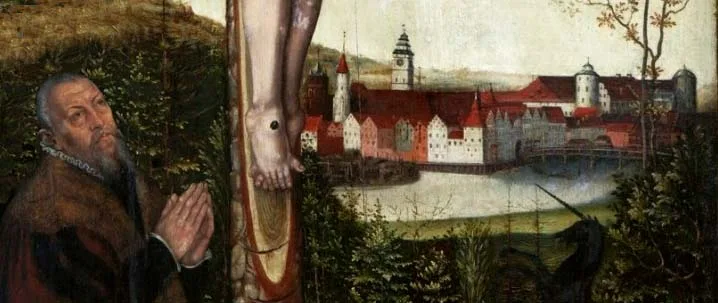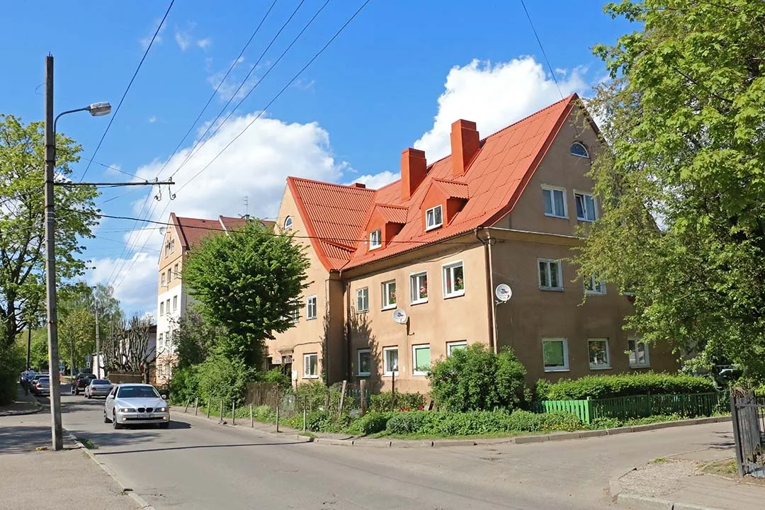
Anyone who wished to settle north of the town rampart could choose the village of Tragheimsdorf for the purpose. Getting to Königsberg from there was far more convenient. Until the first resorts appeared on the Baltic coast (second half of the 19th century), the traffic of passengers and goods along the roads towards Cranz / Cranz (Zelenogradsk), Neukuhren / Neukuhren (Pionersky) and Rauschen / Rauschen (Svetlogorsk) was minimal. There was no demand here for inns or warehouses, and so no reason for settlements to spring up along the roads. Trade flows, as it were, skirted this territory, arriving in Königsberg from the south and turning east within it. Even the village that did form here was a settlement scattered over the territory, made up of separate farmsteads.
In the 19th century Tragheimer Palve was a village which from 1818 formed a rural municipality in the Landkreis of Königsberg / Königsberg (merged into the Landkreis of Samland / Samland in 1939). The village belonged to the parish of the Altrossgarten Church / Altroßgärter Kirche in Königsberg. In 1871 Tragheimer Palve had six dwelling houses with 17 families living in them. On 1 September 1889 a railway station was opened on the southern edge of Tragheimer Palve. It was on the newly opened Königsberg–Labiau / Labiau (Polessk) line. In the last years of the 19th century the street network of the future city district began to take shape in Tragheimer Palve. And although this territory still remained a rural municipality, de facto it was already ceasing to be counted as farmland.
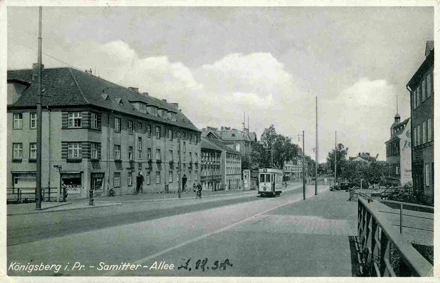 Samitter Allee (Gorkogo Street) in the 1930s.
In 1908 Tragheimer Palve was incorporated into Königsberg and became a city district.
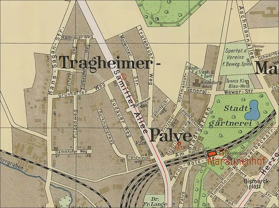 Tragheimer Palve on a 1938 map of Königsberg.
This district developed more slowly than Ratshof / Rathshof (the settlement of Vozdushny) or Devau / Devau (the settlement of Rizhskoye), which lay further from the city centre. The point is that, unlike the new parts of the city mentioned above, there was no plan here to create a comfortable garden city. It was intended that the district would be built up with two- and three-storey apartment buildings, mostly terraced, and that only on the periphery would the development give way to private or two-family houses with small plots of land. At first construction went ahead at a good pace, but the outbreak of the First World War and then the prolonged economic crisis of the Weimar Republic did not favour urban development. As a result, only the central Samitter Allee / Samitter Allee (Gorkogo Street) was fully built up; the other streets were built up the less, the further they lay from the centre of the district. Interestingly, many streets were given names connected with villages and estates lying mostly north of Tragheimer Palve, which could be reached from the city by driving through this district. But one should not assume that a given street led directly to the place associated with it. It is also notable that most of these streets never became "streets" (Straße) by name, and more often remained "ways" (Weg).
In the same year, 1908, on the border of Tragheimer Palve and Maraunenhof / Maraunenhof (Bolshiye Prudy), a municipal horticultural establishment was created on the initiative of Paul Kaeber / Kaeber (1869–1919), professor in the department of higher plants at Königsberg University. It served for practical classes for students and schoolchildren, for growing plants and supplying them to schools, for building up a dendrological collection and for organising excursions for citizens in order to popularise glasshouse horticulture and develop interest in greening the city.
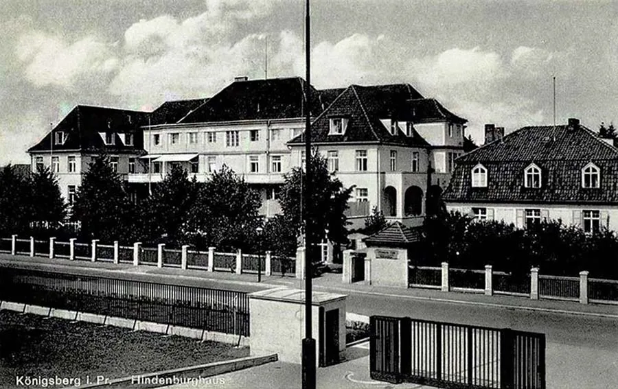 The Hindenburghaus clinic on Höftmannstraße (see below).
In 1927 a tram line was laid to Tragheimer Palve for route No. 8, which ran here from the crematorium.
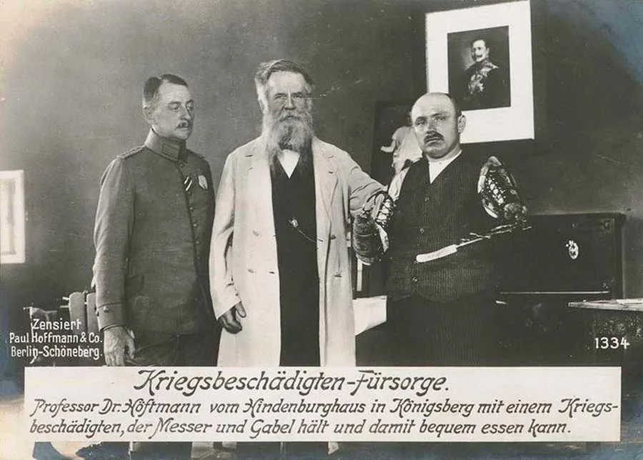 Professor Höftmann with patients at the Hindenburghaus clinic.
In 1933 the tram line was extended to Grünhoffer Weg / Grünhoffer Weg (Zelyonaya Street). At the same time the tram route was replaced by No. 5, which started from the Main Railway Station.
In 1929 Tragheimer Palve railway station was closed. Presumably the city authorities and the railway administration decided that the residents of Tragheimer Palve had now become real burghers and could use the city stations on the same terms as everyone else, and that they had the tram for trips into town. Meanwhile the city had "stepped over" Tragheimer Palve, and soon the district was no longer even on the outskirts. However, looking at the last pre-war city plans, one notices that this corner of the city was never built up as planned.
During the Second World War the pace of construction fell to a bare minimum, in strict accordance with the motto of the time, "guns instead of butter". The bombing raids of the British Royal Air Force did not affect Tragheimer Palve. But during the storming of Königsberg (6–9 April 1945) the streets of the district came under artillery fire and attacks by front-line aircraft. The city commandant regarded Samitter Allee as a dangerous axis along which the Red Army could drive straight into the city centre. And although the fiercest fighting did not, after all, take place here, no less than a third of the buildings of Tragheimer Palve were destroyed so badly that restoration was out of the question.
After the fighting ended, Tragheimer Palve was included in the 2nd district of Königsberg (the 2nd military commandant's office). It was also the military who, in November 1945, carried out the first renamings of the district's streets, many of which were quite successful and have survived to this day. The destruction caused by the fighting during the storming of the city can be described in this district as "moderate". Some streets were destroyed down to the last house, while others suffered only minor damage and could be fully restored.
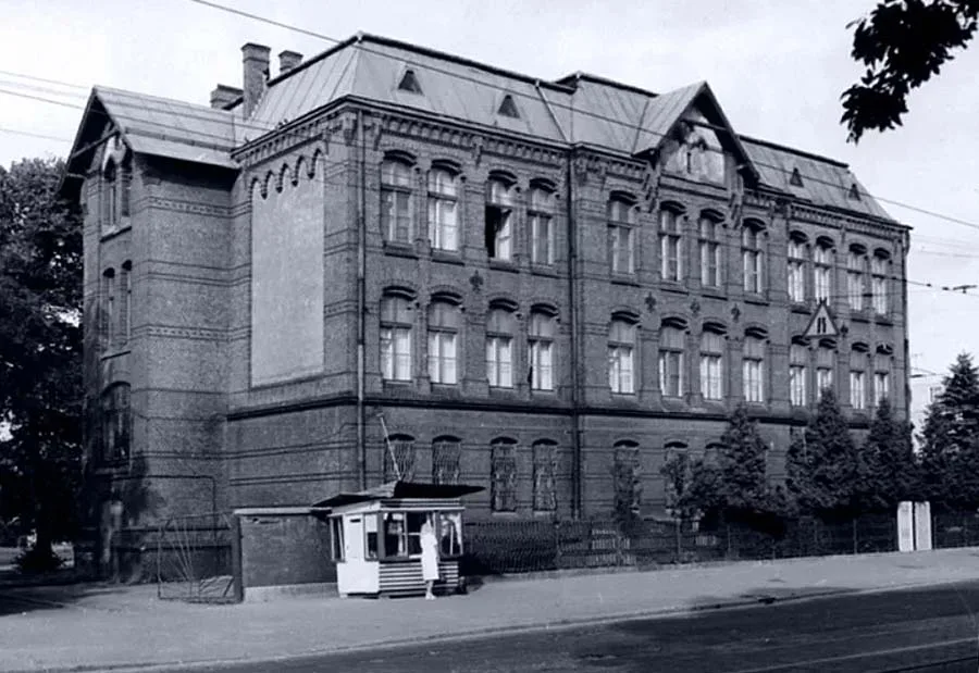 The Ottokar School in the 1970s.
On 6 October 1946 Secondary School No. 7 opened in the former Ottokar Elementary School / Ottokar-Schule.
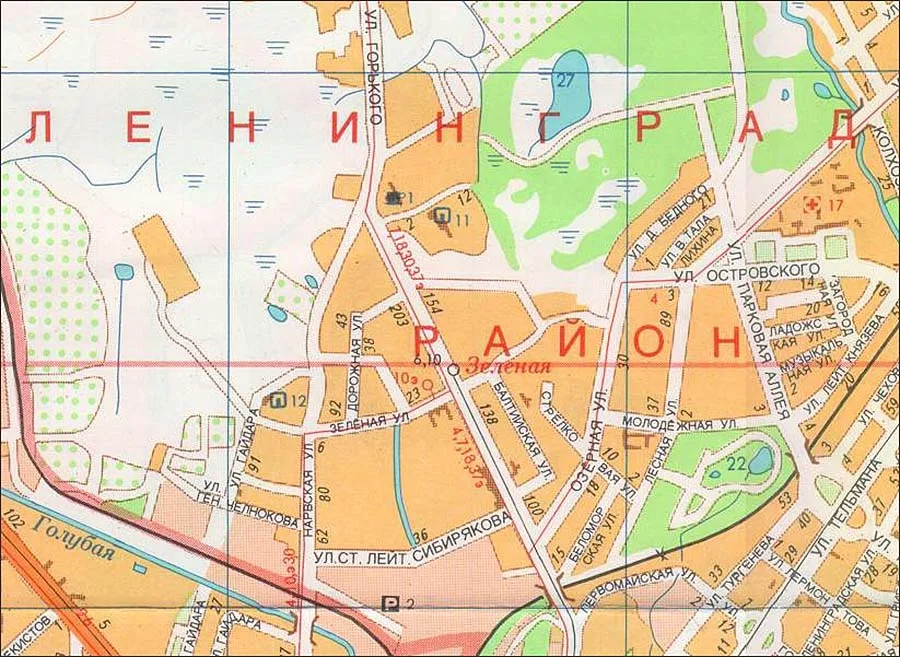 The district on a map of Kaliningrad.
Later the same building also housed School for Working Youth No. 14. In 1948 the Research Station for Green Construction (the future Botanical Garden) was set up on the basis of the pre-war municipal horticultural establishment.
On 18 August 1949, by decision of the Kaliningrad City Executive Committee, Tragheimer Palve was renamed the settlement of Pobednoye, part of the Leningradsky district of Kaliningrad. Of all the renamings, this was perhaps the least successful. The city's population did not take to the new name; it existed only on city plans, and within rather vague boundaries. Around the early 1990s the place name Pobednoye was finally forgotten and disappeared even from maps.
In February 1956 the Research Station for Green Construction was abolished, and the Municipal Nursery for Green Spaces was opened in its place. On 14 November 1957 it was turned into the Botanical Garden and transferred to the Department of Public Education.
In 1961–62 the first post-war buildings were erected in the former Tragheimer Palve: six houses on Narvskaya Street and one house on Admirala Makarova Street. By 1964 tram services had resumed along Gorkogo Street to the turning loop on Zelyonaya Street. Route No. 6 consistently ran here from the loop on Basseynaya Street. From time to time route No. 10 also ran to the loop on Zelyonaya. At about the same time, in 1964, the first pharmacy appeared in this part of the city (Gorkogo Street 120). In 1972 School No. 7 moved to a new building, and from September 1973 the former Ottokar Elementary School housed the Regional Museum of Local History. The only pre-school institution in the district was a crèche in a pre-war building (Narvskaya Street 78).
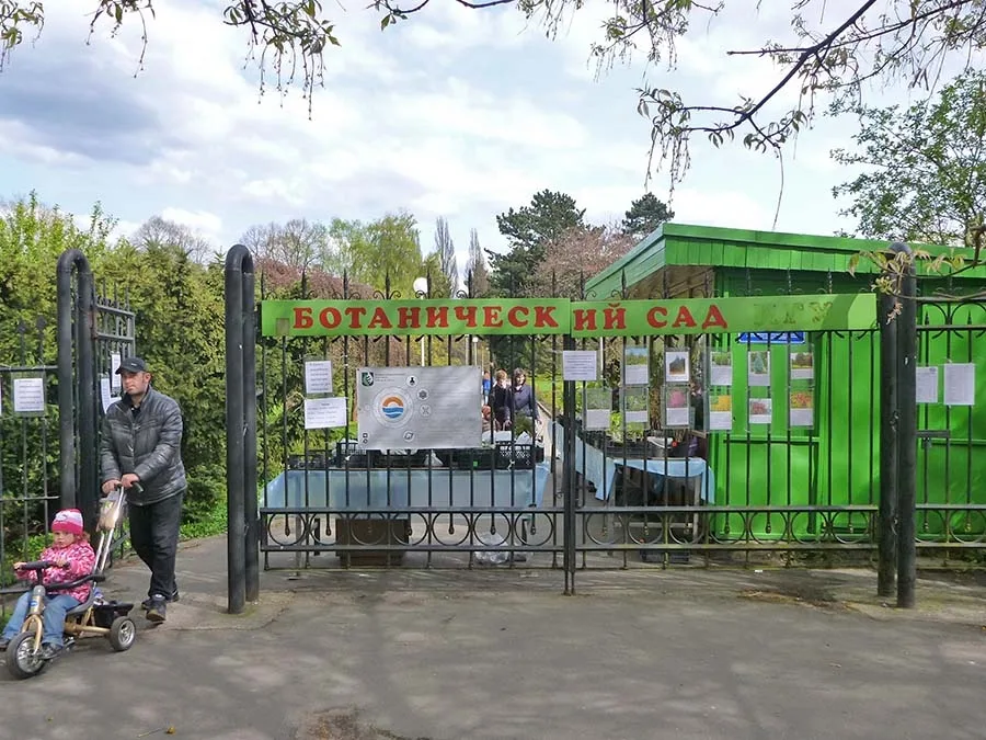 The main entrance to the Botanical Garden.
Until the end of the 1970s and even in the early 1980s this part of the city left a strange impression: the pre-war buildings on Gorkogo Street had been restored, but the streets branching off it ended in vast wastelands.
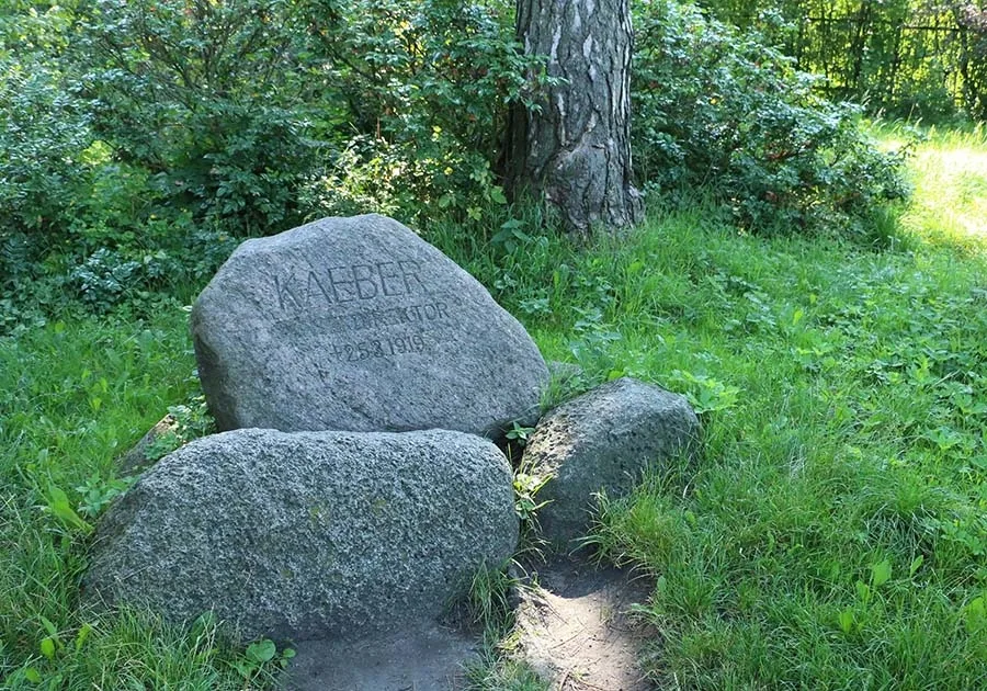 The Paul Kaeber Memorial in the Kaliningrad Botanical Garden.
The Tragheimer Palve district had looked much the same in the 1920s. There was nothing surprising in this, because apart from the seven houses on Narvskaya and Admirala Makarova Streets, no building took place here until 1976, when one house was built (Gorkogo Street 107). But then, in 1977–79, a whole block (12 houses) was erected between Zelyonaya and Lugovaya Streets (now Starshego Leytenanta Sibiryakova Street). Construction continued in the 1980s. Besides residential houses, kindergarten No. 134 (1985) and School No. 38 (1986) were built at that time.
In 1991 the local history museum changed its address once again, moving to the former Stadthalle on the bank of the Lower Pond. The Children's Music School (now the Frédéric Chopin Children's Art School) moved into the vacated building of the Ottokar Elementary School.
Building in the former Tragheimer Palve continued in the 1990s, 2000s and 2010s; in some places undeveloped land was used, in others pre-war buildings were demolished. Today there are quite a number of shops and catering establishments within the boundaries of Tragheimer Palve, as well as pharmacies and a post office. If anything is lacking, it is open space and green areas.
As of 2024, 78 pre-war buildings have survived in the former city district of Tragheimer Palve. Of these, one building – the Ottokar Elementary School – is a registered architectural monument.
Sights:Immanuel Kant Baltic Federal University Botanical Garden
Population of the village of Tragheimer Palve: 1867 – 57, 1871 – 60 inhabitants.
Composition of the population of Tragheimer Palve in 1871: all 60 Evangelical Christians, children under 10 – 17, literate – 22 (of 39 surveyed, 56%).
Streets of the Tragheimer Palve district as of 1928–32
Am Stadtgarten / Am Stadtgarten, a long street (2.6 km) running along the border of the Botanical Garden and Max Aschmann Park. Only the southern part of the street belonged to Tragheimer Palve. On 23 November 1945 it was renamed Oktyabrskaya by order of the commander of the troops of the Special Military District. However, on 1 August 1946 the City Civil Affairs Administration approved a different name – Lesnaya Street. 13 pre-war buildings have survived on it.
Bergenauer Weg / Bergenauer Weg, a short lane crossing Samitter Allee. It was named after the Bergenau manor farm (now part of the settlement of Kudrinka). After the war it was renamed Krymsky Pereulok, but after 1983 this name disappeared from city maps. Today it is a nameless passage between houses No. 126a and No. 130 on Gorkogo Street, where one pre-war building has survived.
Beydritter Weg / Beydritter Weg came into being at the beginning of the 20th century but was never fully built up with houses before the war. It was named after the village, and later city district, of Beydritten (Pervomayskoye). During the storming of the city the blocks adjoining Samitter Allee were completely destroyed. On 23 November 1945 it was renamed Aprelskaya Street by order of the commander of the troops of the Special Military District. On 1 August 1946 the Civil Affairs Administration renamed the street Belomorskaya. Today three pre-war buildings survive on Belomorskaya Street. The other houses were built in 1998–2008.
Borkmühlenweg / Borkmühlenweg came into being at the beginning of the 20th century on the line of an old road. It was named after the Borkmühle / Borkmühle estate (in the area of today's Gospitalnaya Street). It was never built up with houses before the end of the war. It was not renamed after the war and disappeared during the subsequent development of the district. Part of the street's route is now followed by a footpath from a house on Starshego Leytenanta Sibiryakova Street to kindergarten No. 134.
Brandwiesenweg / Brandwiesenweg came into being at the beginning of the 20th century, but before the war only the beginning of the street, adjoining Samitter Allee, was built up. During the storming of the city all the houses on the street were badly damaged. On 23 November 1945, by order of General Galitsky, commander of the troops of the Special Military District, it was renamed Sukhopolnaya Street. On 1 August 1946 the Civil Affairs Administration assigned the street a new name – Lugovaya Street. But in connection with the construction of a municipal district-heating station, this street ceased to exist at the turn of the 1970s and 80s. Today it is the road from Gorkogo Street to the Severnaya district heating station. At the beginning of the street one pre-war building has survived, which belongs to Gorkogo Street.
Grünhoffer Weg / Grünhoffer Weg came into being in the 1910s. Before the war houses appeared on it only in its eastern part. For the most part they were not badly damaged during the fighting and were repaired after the war. On 23 November 1945 Grünhoffer Weg was renamed Promezhutochnaya Street by order of the commander of the troops of the Special Military District. However, the Civil Affairs Administration did not like this name, and on 1 August 1946 the street was renamed Zelyonaya. Today Grünhoffer Weg is Zelyonaya Street east of Gorkogo Street. Two pre-war houses have survived on the street.
Dammhoffer Weg / Dammhoffer Weg was, as late as the beginning of 1927, considered a continuation of Brandwiesenweg beyond Tragheimer Palve. When on 16 June 1927 the territory where it lay became part of Königsberg, the street began to be counted as part of Tragheimer Palve, and its name was changed after Dammhof / Dammhof (54°38'48'' N 20°34'31'' E). Before the war it was only partly built up with houses. After the war it was not officially renamed, but in fact became part of Lugovaya Street. Around 1980 Lugovaya became Starshego Leytenanta Sibiryakova Street, and the former Dammhoffer Weg its western part. One pre-war building has survived on Dammhoffer Weg.
Dammteichweg / Dammteichweg was named after the lake Dammteich / Dammteich (Lake Divnoye near the settlement of Petrovo). It was never fully built up with houses before the war. After the fighting ended, three houses on the street remained relatively undamaged. On 1 August 1946 Dammteichweg was renamed Baltiyskaya Street. However, the present-day Baltiyskaya Street coincides with Dammteichweg only at house No. 2–4, which is the only surviving pre-war building on Dammteichweg.
Dieffenbachstraße / Dieffenbachstraße was named in honour of Johann Friedrich Dieffenbach (1792–1847), a German surgeon and pioneer of transplantation and plastic surgery, who was a native of Königsberg and graduated from the medical faculty of the Albertina. In 1936 the street was extended to Aschmann Allee / Aschmann Allee (Parkovaya Alleya) and renamed by the Nazis General-Wever-Straße / General-Wewer-Straße after Walther Wever / Wewer (1887–1936), one of the founders of the Luftwaffe. The street was relatively undamaged during the fighting. On 23 November 1945 it was renamed Molodyozhnaya by order of the commander of the troops of the Special Military District and has kept this name to this day. There are now six pre-war buildings on the former Dieffenbachstraße.
Samitter-Allee / Samitter-Allee was the main street of Tragheimer Palve, though only part of this long Königsberg street (4.1 km) belonged to the district. It is also the oldest street in the district, since it arose on the line of the road running from Königsberg through Tragheimer Palve to the Samitten / Samitten estate (54°47'00'' N 20°28'40'' E). Not surprisingly, this street was the most built-up in the district. It was on this street, too, that the building of the Ottokar Elementary School was erected in 1890–1900.
During the storming of the city on 6–9 April 1945, the part of the street lying in Tragheimer Palve was badly damaged, losing roughly half of its buildings as a result. After the war, on 23 November 1945, it was renamed Kursantskaya Street by order of the commander of the troops of the Special Military District; however, the Civil Affairs Administration found another place in the city for Kursantskaya (today's Rokossovskogo Street), and Samitter Allee was renamed once more, as Gorkogo Street. Today 23 pre-war buildings survive on the former Samitter Allee, 13 of them in the Tragheimer Palve district. This street has the district's only building recognised as a cultural heritage site – the building of the Ottokar Elementary School.
Sudauerweg / Sudauerweg came into being at the beginning of the 20th century, but before the war it was hardly built up at all. The name is connected with the Sudau / Sudau estate (the settlement of Maykovo). Because so few houses had been built, it was not renamed after the war. It disappeared completely when prefabricated panel houses were built in 1977–79.
Kaeber-Straße / Kaeber-Straße, a small lane leading to the Botanical Garden. It was named in honour of the founder and first director of the municipal horticultural establishment, Professor Paul Kaeber / Kaeber (1869–1919). After the war it was renamed Aleksandra Bloka Street, but between 1960 and 1964 it disappeared from city plans. Today it is a nameless dead-end path along the railway tracks, leading up to the fence of the botanical garden. There are no buildings on it.
Langenbeck Straße / Langenbeck Straße was named in honour of Bernhard Rudolf Konrad von Langenbeck (1810–87), a German military surgeon and the creator of surgical residency training. It came into being in the 1920s. Its houses suffered relatively little during the storming of the city. On 23 November 1945 it was renamed Krasny Put Street by order of the commander of the troops of the Special Military District. However, the City Civil Affairs Administration found this name not very suitable, and on 1 August 1946 Krasny Put was renamed Strelkovaya Street. Four pre-war buildings have survived on the former Langenbeck Straße. The present-day Strelkovaya Street is somewhat longer (to the north-west) than the pre-war Langenbeck Straße.
Mischener Weg / Mischener Weg was named after the Gross Mischen / Groß Mischen estate (the settlement of Svobodnoye). The street came into being in the early 1930s and was soon built up with terraced houses. It suffered relatively little during the storming of the city. On 23 November 1945 it was renamed Dorozhnaya Street by order of the commander of the troops of the Special Military District. The name has survived to the present day. To this day (2024), five pre-war buildings survive on the street.
Mollenner Straße / Mollenner Straße came into being at the beginning of the 20th century, but before the war only two apartment buildings were built on it. After the war it was renamed Vereshchagina Street. For a long time its only pre-war house stood alone on it. Only in 1987 was Vereshchagina Street built up with panel houses, after which it came to coincide only partly with the pre-war Mollenner Straße. But one pre-war house has nevertheless survived on it.
Nadrauer Weg / Nadrauer Weg was named after the Nadrau / Nadrau estate (Nizovka). Before the war only one apartment building was built on the street, and even that was destroyed during the storming of the city. After the war Nadrauer Weg was renamed Pyatigorskaya Street. The street existed until the early 1990s, and finally disappeared when Gaidara Street was widened and a roundabout was built at the intersection of Gaidara and Gorkogo Streets.
Pilzenweg / Pilzenweg lay outside Tragheimer Palve until 1927, but when on 16 June 1927 this territory became part of Königsberg, Pilzenweg came to be counted as part of Tragheimer Palve. According to the cadastral plan, there were 30 building plots on the street, but only six houses had been built by the start of the war. On 23 November 1945 it was renamed Gribnaya Street, a translation of the German name, by order of the commander of the troops of the Special Military District. However, on 1 August 1946 the Civil Affairs Administration renamed Gribnaya Street Admirala Makarova Street. The pre-war houses stood here until the 1970s, but then all of them were demolished, and in 1977–87 the street was built up with prefabricated panel apartment blocks.
Trutenauer Weg / Trutenauer Weg. This name was connected with the village of Trutenau / Trutenau (the settlement of Medvedevka). The street appeared on city maps in the 1920s but was never fully built up; by 1944 it had only seven houses, five of which were destroyed during the storming of the city. On 23 November 1945, by order of Galitsky, commander of the troops of the Special Military District, it was renamed Pervomayskaya Street. This name was not approved, and on 1 August 1946 the City Civil Affairs Administration gave the street the name Krymskaya Street. It finally disappeared in 1987–91 when houses were built on Baltiyskaya and Zelyonaya Streets.
Fritzener Weg / Fritzener Weg came into being at the beginning of the 20th century and was named after the head forestry office of Fritzen / Oberförsterei Fritzen (the settlement of Sosnovka in the Guryevsk district). Before the war it was about 80% built up. The houses on Fritzener Weg were badly damaged during the storming of the city on 6–9 April 1945. After the war, by order of the commander of the troops of the Special Military District of 23 November 1945, it was merged with Höftmannstraße and renamed Lesnaya Street. But, as happened more than once, a different street nearby became Lesnaya Street, and on 1 September 1946 Fritzener Weg and Höftmannstraße were renamed once again, as Ozyornaya Street. Today Fritzener Weg is the part of Ozyornaya Street from Gorkogo Street to Strelkovaya Street. Four pre-war houses have survived on the street.
Hans-Sagan-Straße / Hans-Sagan-Straße appeared in the 1910s in the Vorder Hufen / Vorder Hufen district. Its continuation to the north bore the name Ernsthöfer Weg / Ernsthöfer Weg, after the Ernsthof / Ernsthof estate (54°44'47'' N 20°30'00'' E) to which this road led. At that time Ernsthöfer Weg lay outside the municipality of Tragheimer Palve. When on 16 June 1927 the territory through which Ernsthöfer Weg ran became part of Königsberg, the street was united under one name with Hans-Sagan-Straße and came to be regarded as the western boundary of the Tragheimer Palve city district. Thus Hans-Sagan-Straße, named in honour of the legendary shoemaker Hans Sagan, hero of the Battle of Rudau (1370), now ran through two city districts at once, and only its northern part can be assigned to the Tragheimer Palve district. On 23 November 1945, by order of General Galitsky, commander of the troops of the Special Military District, the street was renamed Narvskaya and has kept this name to this day. There are now 19 pre-war buildings on Hans-Sagan-Straße, 15 of them in Tragheimer Palve.
Höftmannstraße / Höftmannstraße came into being after 1907 as a road leading to the Tragheim cemetery. It received its name in 1923 in honour of Heinrich Höftmann (1851–1917), a Prussian orthopaedic physician and founder of the German Orthopaedic Society. The Hindenburghaus / Hindenburghaus clinic, where he worked, faced the future Höftmannstraße with one wing. Höftmannstraße was not damaged during the storming of the city. By order of the commander of the troops of the Special Military District of 23 November 1945 it was merged with Fritzener Weg into Lesnaya Street, but on 1 September 1946 its name was changed to Ozyornaya Street. Today it is the part of Ozyornaya Street from Strelkovaya Street to Ostrovskogo Street. Seven pre-war buildings have survived on the street, including the Hindenburghaus clinic (now the "Na Molodyozhnoy" children's and youth centre).
Zielkeimer Weg / Zielkeimer Weg was named after the Zielkeim / Zielkeim estate (the settlement of Petrovo). The street came into being at the turn of the 1920s and 1930s and by the start of the war was half built up with terraced houses. It suffered relatively little during the storming of the city. After the war it was renamed Bakhchisarayskaya Street. One pre-war building has survived on the street to this day.
Modern photos on this page: Mikhail Ogorodnikov
Translated from Russian with the help of AI (Claude, Anthropic), October 2026.