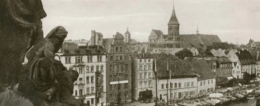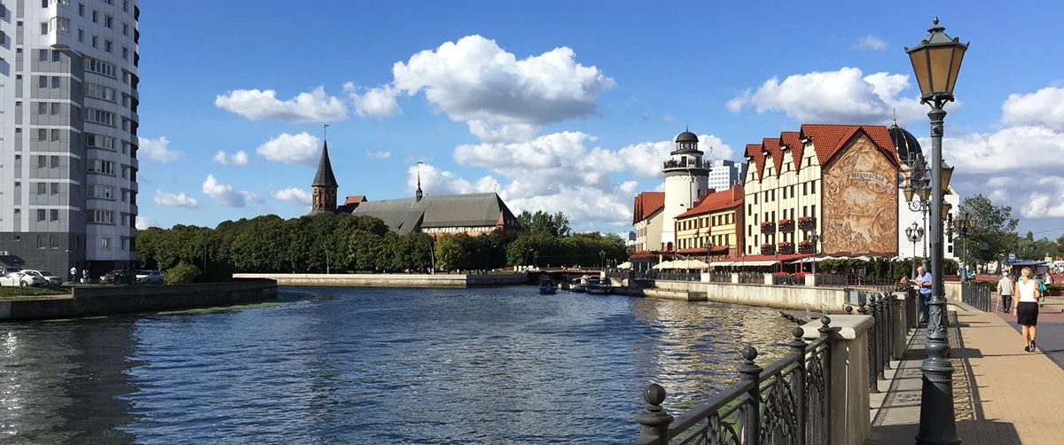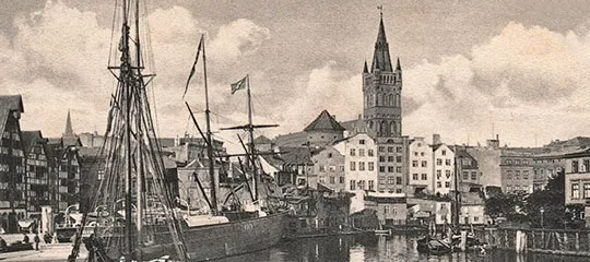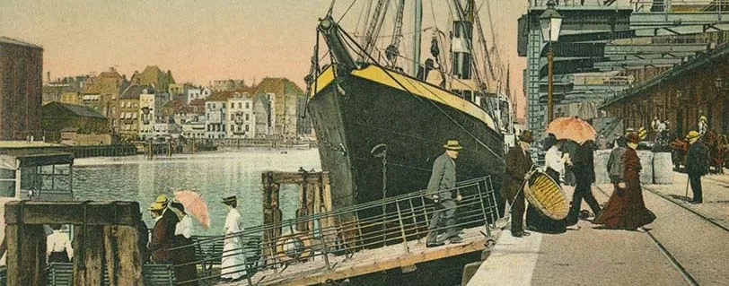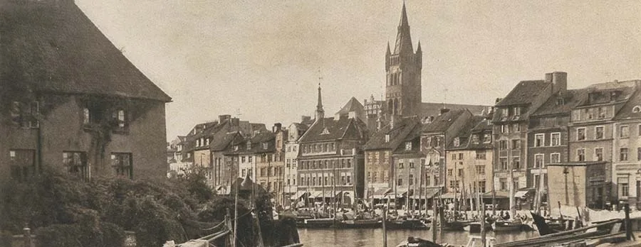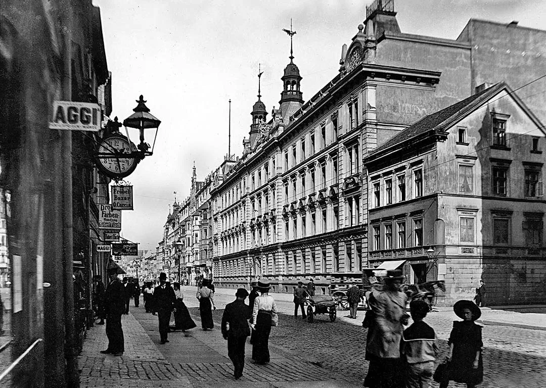
Many medieval towns had suburbs of this kind. They were called Freiheiten (Freiheit), which translates as "freedom" and is a calque of the Russian word "sloboda", which likewise derives from the word "svoboda" (freedom). The connection with the notion of freedom probably arose because municipal law, and the restrictions that came with it, did not extend to these territories. Anyone who conducted business here, and later built residential quarters, could count on certain concessions compared with the strictly regulated urban order.
Originally the freedoms were not intended for permanent residence. And it was above all the municipalities themselves that opposed people settling there. After all, any settler at the town walls was, in one way or another, a competitor to the guilds and to individual craftsmen of the town. And competition in those days was regarded as an evil that lowered the price level so advantageous to the municipalities and had a negative effect on the quality of goods.
Nevertheless, people began to settle in the Freiheiten practically from the first years of their existence. At first these were watchmen and temporary hired labourers; then property owners also began to build houses here: some illegally, others obtaining legal status through a bribe or some service rendered to the municipality.
In any case, exceptions to the general rule began to be made systematically, and they quickly became the rule. However, under the laws of the time, people living in the Freiheiten were not burghers. On the other hand, they belonged to the church congregation of the town that owned the Freiheit. And even if a church was built in a Freiheit, it did not form a parish of its own or acquire its own congregation. Such a church was considered a "branch" of the town church, or a "daughter church". One way or another, we can state the fact: soon after its establishment the Vorstadt became a place of permanent residence. It is a curious fact that geographically the Vorstadt already lay in Natangia, yet its inhabitants belonged to the parish of the cathedral in Kneiphof, which belonged to the Diocese of Samland, being its principal church. Incidentally, the name Vorstadt itself is an example of a common noun turning into a proper name. In Russian, Vorstadt means "fore-town", "front town", which differs somewhat in spirit and word formation from our familiar notions of a "suburb" or an "out-of-town" area.
The Vorstädte of German towns, as it were, preceded the entrance into the town, and fortified Vorstädte also served as a forward line of defence that an enemy had to take before besieging the town itself. But the Kneiphof Vorstadt was not fortified; at first it was simply called the Kneiphof Vorstadt, until the name Vorstadt became a proper name.
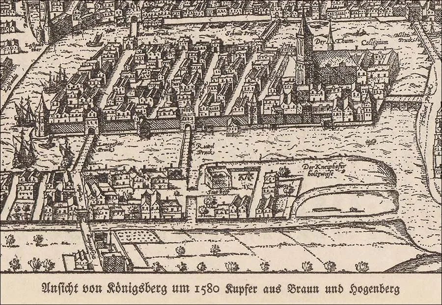 The Vorstadt (in the foreground) on a map of Königsberg (1580).
As early as 1322 the ferry crossing over the Old Pregel (from Kneiphof to the Vorstadt) was replaced by a bridge that was later called the Green Bridge (Grüne-Brücke).
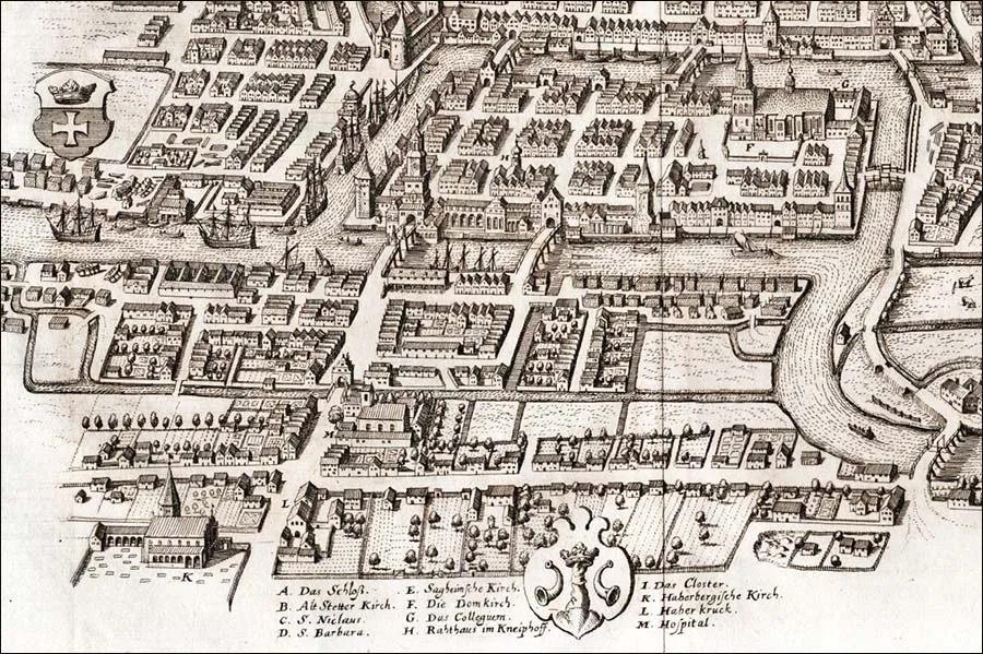 The Vorstadt on a map of Königsberg (1613).
It received this name not because of a green colour or any landscaped greenery around it, but after the main colour of the coat of arms of Kneiphof, to which the bridge belonged. In the Vorstadt, west of the Green Bridge on the bank of the Pregel, there was a quay where the Green Crane operated – a mechanical device for unloading ships. The name of the crane also came from the coat of arms of Kneiphof.
On 3 September 1329 the Order's chancery issued a charter establishing the Hospital of St George, which was apparently a condition for granting the Vorstadt to Kneiphof. Obligations of this kind, connected with placing churches, monasteries and hospitals on town land or land administered by a town, were widely used in the Order's state. The main street of the Vorstadt began at the Green Bridge and was a continuation of the Kneiphof Langgasse.
Since the development of the Freiheit began precisely with this street, it received an unpretentious name – Vorstadt, like the whole district. It was also called Vorstädtische Langgasse (Vorstädtische Langgasse); this name became official and the only one at some point in the 18th century.
In 1376 another hospital, St Anthony's, was built in the northern part of the Vorstadt. Next to it a chapel of the same name was erected, but this was a hospital church, not the church of the freedom. Because of this, the northern (more built-up) part of the Vorstadt came to be called the "Vorstadt of St Anthony", as opposed to the southern part, which was called the "Vorstadt of St George".
In 1377 a second bridge was built between Kneiphof and the Vorstadt, which later received the name Giblets Bridge (Köttel-Brücke / Köttel-Brücke). Like the Green Bridge, it belonged to Kneiphof and was controlled by it, so it can be assumed that the reason for building a new bridge only 120 metres from the existing one was the increased flow of goods (including transit goods) between Kneiphof and the Vorstadt. Both bridges were fortified only on the Kneiphof side, where defensive gates stood on them. The Vorstadt had no fortifications at all, and so in 1455, during the anti-Teutonic rising in Kneiphof, it was occupied without a fight by a detachment of the Order for a three-month siege of Kneiphof.
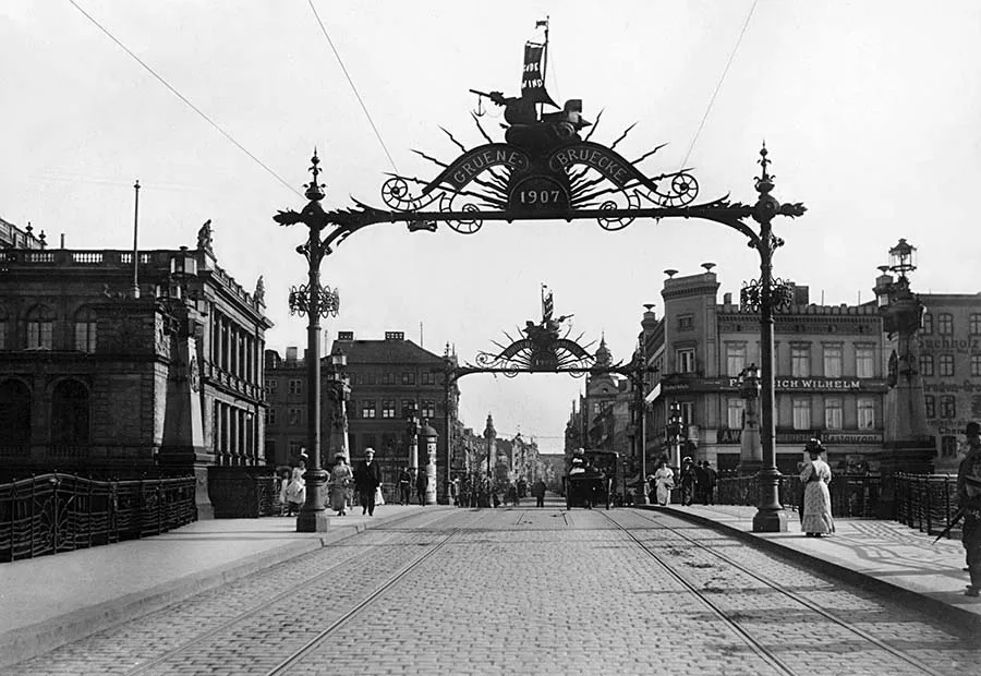 The Green (above) and ...
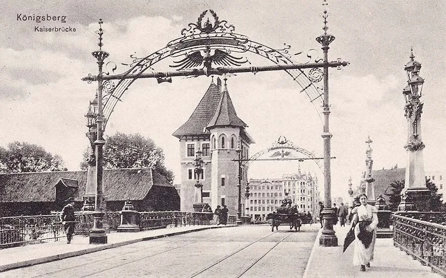 ... the Imperial bridges connected the Vorstadt with the islands of Kneiphof and Lomse.
The Vorstadt had no church of its own until the turn of the 19th and 20th centuries. The population of the Freiheit was considered part of the Kneiphof congregation and attended the Cathedral on the island.
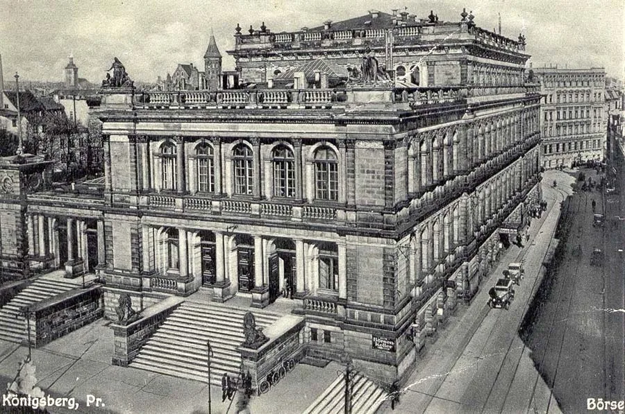 The Königsberg Stock Exchange on the bank of the Pregel in the Vorstadt.
Recalling the events of the siege of Kneiphof in 1455, it should be noted that before surrendering the Vorstadt to the troops of the Order and the Altstadt citizens loyal to it, the inhabitants of the Vorstadt set fire to the freedom themselves and then took refuge in Kneiphof. Incidentally, it was then that the Hospital of St George burned down for the second time (but far from the last).
In general, fires were a real scourge of medieval towns and especially of suburbs. In the suburbs this was aggravated by the fact that a considerable proportion of the buildings were made entirely of wood, combustible materials (timber, coal, flour, grain) were stored in them, and work with open fire, such as tarring boats, was carried out nearby. In the Vorstadt one such fire occurred in 1513, when the greater part of it burned down. In 1520 the next major fire broke out. In the same year work began on creating a system of canals in the Vorstadt. Besides improving the situation with the high groundwater, a Vorstadt divided by canals would be less of a fire hazard.
The first to be built was the central canal, the Zuggraben / Zuggraben, which divided the Vorstadt into two parts – the Front Vorstadt / Vordere Vorstadt and the Rear Vorstadt / Hintere Vorstadt.
Frankly, these names raise questions. Thus Vordere Vorstadt translates literally as "Front Fore-Town", which is a tautology in itself. And geographically the "Front Fore-Town" lay beyond the "Rear Fore-Town". But such was the logic of place-naming in the port cities of the Middle Ages and the Renaissance, when those travelling overland were orders of magnitude fewer than those who set off on long journeys by river and sea.
But let us return to the system of canals. The Zuggraben began at today's Jubilee Bridge, where it joined the waters of the Pregel; it then ran exactly along today's Krasnooktyabrskaya and Polotskaya Streets and came out to the Pregel again near the Old Railway Bridge opposite the Museum of the World Ocean. The Zuggraben was 10–15 metres wide. The canal was navigable for boats and small barges. The water in it had a slight current, which prevented it from turning into a swamp and somewhat improved its quality, since all the town's sewage ended up in the canals one way or another.
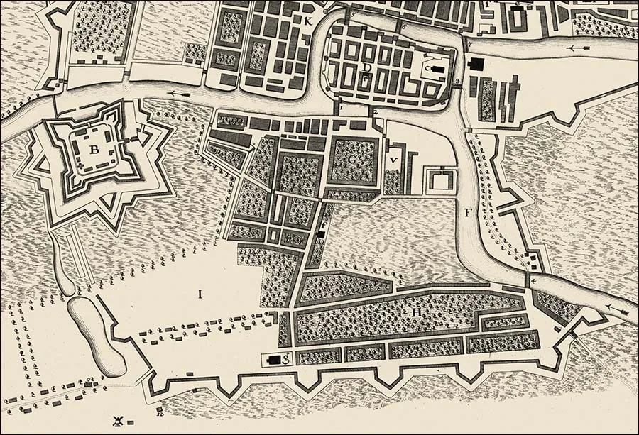 The Vorstadt on a map of Königsberg (1763).
Since the construction of the Zuggraben coincided with the outbreak of the Cavalry War (1519–21), its bank was reinforced with a palisade of logs in order to offer at least some resistance to Polish raids. Where the main street, Vorstädtische Langgasse, crossed the Zuggraben, a bridge was built that was called the Zugbrücke / Zugbrücke. It was a drawbridge, to let barges through.
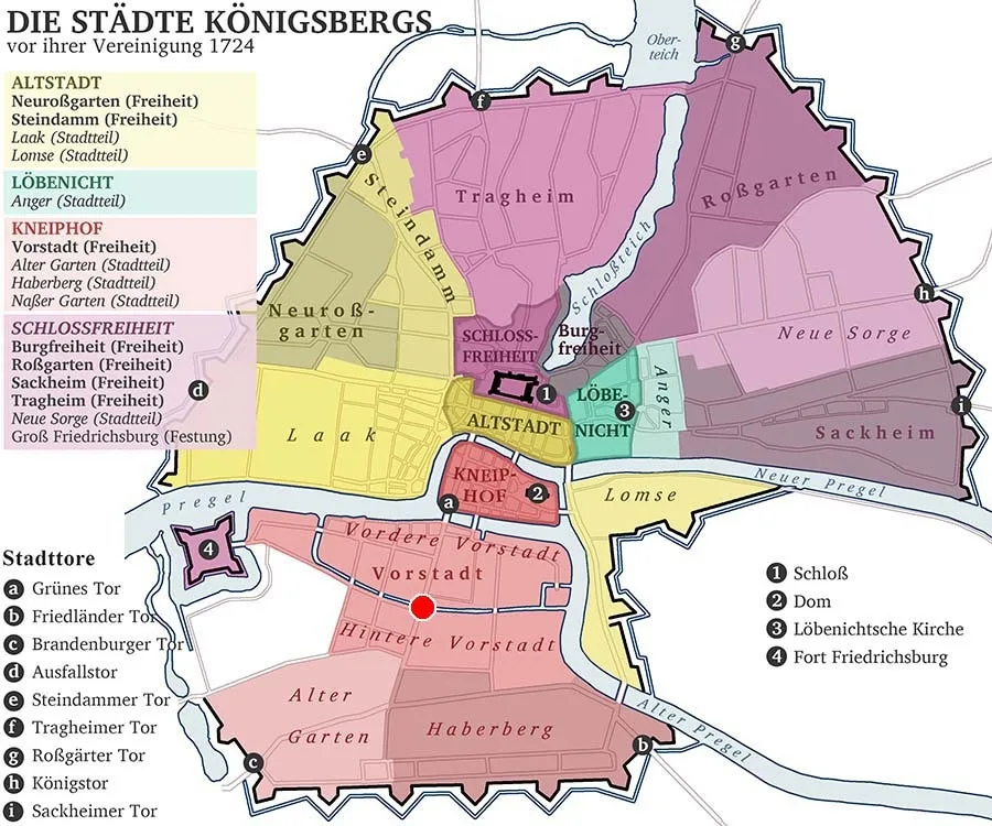
The Vorstadt on a reconstructed map of the towns, freedoms and districts of Königsberg before their unification in 1724.
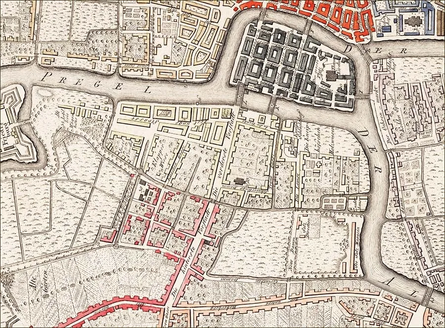 The Vorstadt on a map of Königsberg (1800).
Near the bridge a Baroque bridge-keeper's lodge was built. There were two more small bridges over the Zuggraben. One, in present-day terms, was in the courtyards behind the Atlantika restaurant, and another at the site of the intersection of Portovaya and Polotskaya Streets. Among the larger canals of the Vorstadt, the canal running along today's Novy Val Street and connecting the Zuggraben with the Pregel also deserves mention. Nearby there was another canal in the shape of the letter "Г" or "L", which likewise began and ended in the Pregel, turning yet another part of the Vorstadt into an island. There were 5–6 more fairly large canals that boats could enter. These canals were connected to the Zuggraben but were dead ends. The remaining canals were small, more like ditches, and were intended for draining the land. Because of the abundance of canals and ditches, the Vorstadt of the 16th–18th centuries was sometimes called Little Venice, but, frankly speaking, the resemblance was rather remote. While the canals were being built, another fire broke out in 1550 – about 100 houses burned down in the Hintere Vorstadt, including the Hospital of St George.
In the 16th century a Fair Square – Jahrmarkt-Platz / Jahrmarkt-Platz – was laid out near the Zugbrücke (on the site of the present-day square by the Marine College), where large fairs were held twice a year.
East of the Jahrmarkt-Platz, water meadows stretched all the way to the Pregel. This area remained undeveloped for quite a long time and was used for grazing cattle. In 1581 a slaughterhouse was built near the Giblets Bridge. In fact, it was from this moment that the Giblets Bridge received its name. Before that it was called the "Shaking" Bridge.
When in 1626–40 the boundaries of the future unified Königsberg were outlined in the form of a ring of ramparts, the Vorstadt found itself in a very advantageous geographical position. It lay not far from the town centre, and its main street was part of the principal overland traffic artery crossing the town from north to south. And although by this time there was a route bypassing the Vorstadt – via the Wood Bridge, Lomse Island and the High Bridge – a considerable part of the freight nevertheless passed through the Vorstadt or arrived at its wharves by river.
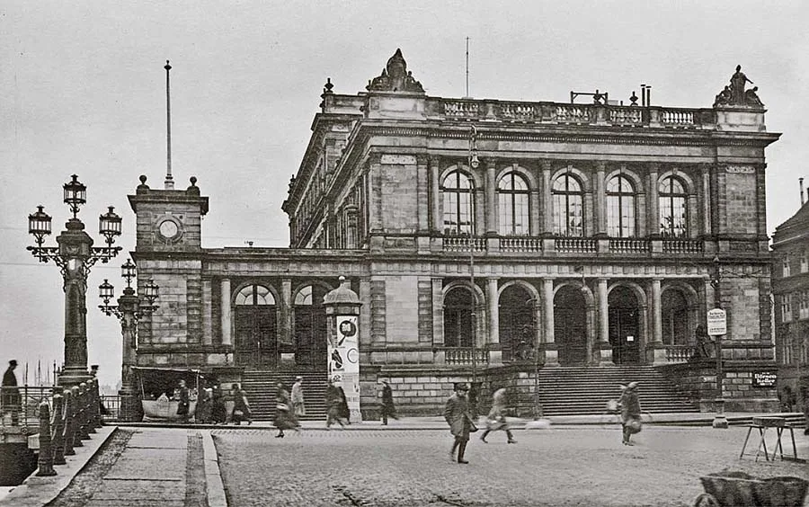 The Königsberg Stock Exchange has become the Museum of Fine Arts.
In 1627 a boom barrier – the "Dutch log" (Holländerbaum / Holländerbaum) – was built on the Pregel at the western edge of the Vorstadt. Next to it, in 1657, the "Great Elector" Frederick William built Fort Friedrichsburg, whose moats became the western boundary of the Vorstadt.
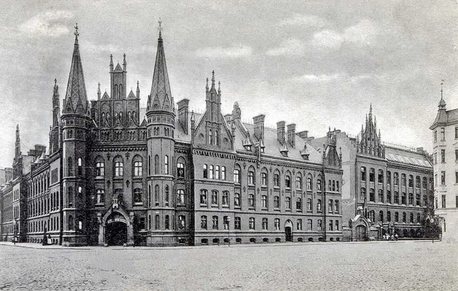 The Hospital of St George patiently awaits its hour.
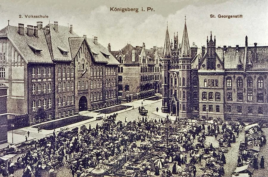 A fair on the square in front of the Hospital of St George.
At the end of the 17th century a large L-shaped salt warehouse was set up in the eastern part of the Hintere Vorstadt near the Pregel (in the area of present-day Epronovskaya Street). The area west of the warehouse was named the Municipal Salt Meadow / Städtische Salz-Wiese. Next to it was the Municipal Storage Yard / Städtische Ablage-Platz. Opposite the salt warehouse, on the other side of the Zuggraben, a prison was built.
On 22 April 1724 Immanuel Kant was born in the Vorstadt, in house No. 22 on its main street. Memories of a childhood spent in the Vorstadt were most likely the reason for the great philosopher's habitual walks along the dam built from the bastions of Fort Friedrichsburg towards the town rampart on the border with Nasser Garten / Nasser Garten (the settlement of Portovoye within the city limits of Kaliningrad).
Kant scholars maintain that the young Kant walked the route along the dam with his mother. This dam later received the name Philosophers' Dam (Philosophen Damm); today it is part of Polotskaya Street by the Pregel and the intersection with Portovaya Street.
Further on, the dam ran along the edge of the market on Polotskaya Street and passed into present-day Elblongskaya Street, heading towards the town rampart on the border with Nasser Garten. The literature on Immanuel Kant states that the great philosopher walked along the dam precisely in the direction of Nasser Garten. Let us accept this as fact, all the more so since his biographers have studied the life of the famous Königsberger literally step by step.
In the same year, 1724, on 13 June, the Vorstadt became a district of unified Königsberg. Now the development of the former Freiheit was no longer hampered by medieval municipal laws. The Vorstadt began to develop above all as an industrial district of the city, where residential houses and industrial enterprises stood side by side.
In 1756 the Jewish community of Königsberg petitioned King Frederick II for permission to build a second synagogue. By this time the community numbered 307 people, and the oldest synagogue, in Tragheim, had become too cramped. Königsberg's Jews were not permitted to live in the towns themselves, but there was no ghetto in Königsberg either.
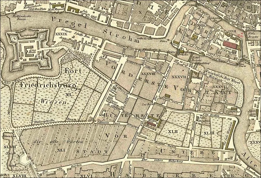 The Vorstadt on a map of Königsberg (1809).
Jews settled in the Freiheiten. Jews who had long been settled in Königsberg lived in Tragheim, while new Jewish settlers arriving here most often chose the Vorstadt as their place of residence.
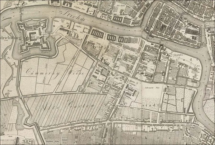 The Vorstadt on a map of Königsberg (1815).
That is why permission was given to build the synagogue in the Vorstadt, which was convenient for those living on the southern bank of the Pregel. The building was erected on Schnürlich-Gasse / Schnürlich-Gasse (today's Parusnaya Street).
In 1769 and 1775 two major fires broke out one after the other. The first destroyed 76 houses and 153 warehouses in the Vorstadt. Of the second it is said that it destroyed 352 warehouses in the Vordere Vorstadt. However, as subsequent events showed, they did not lead to a radical revision of fire-prevention measures or a reorganisation of the city's fire service. A paradoxical situation arose in which a district located on a system of canals, where access to the main means of fighting fire – water – was entirely unobstructed, burned down quarter by quarter.
On 14 June 1811 yet another tremendous fire broke out in the Vorstadt, virtually destroying this part of the city. Houses, warehouses, the synagogue and the Hospital of St George burned down. Among others, the house where Immanuel Kant was born and grew up burned down too.
The fire occurred at a difficult time for Prussia, when it was effectively occupied by the French and was de jure (not of its own will) an ally of Napoleonic France. Nevertheless, even under these conditions, work on rebuilding the Vorstadt began immediately after the fire. In particular, it is noted that as early as 19 April 1815 a new synagogue was opened to replace the one that had burned down, though on a different site. It now stood between Vorstädtische Langgasse (part of Leninsky Prospekt) and Schnürlich-Gasse (Parusnaya Street). At the same time as the synagogue was built, these streets were connected by a short lane, Synagogen Gasse / Synagogen Gasse. In present-day terms, the synagogue and Synagogen Gasse were in the courtyard of the building at 1–7 Krasnooktyabrskaya Street. The old outbuildings destroyed by the fire made room for the development of industries and infrastructure that were modern for the time.
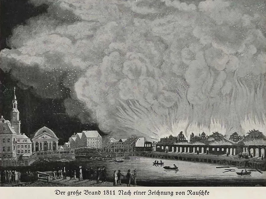 Fire in the Vorstadt (1811).
On 2 August 1853, in the eastern part of the Vorstadt, on the newly completed Prussian Eastern Railway (Preußische Ostbahn) leading to Braunsberg / Braunsberg (Braniewo) and on to Berlin, the Eastern Station (Ostbahnhof) was opened.
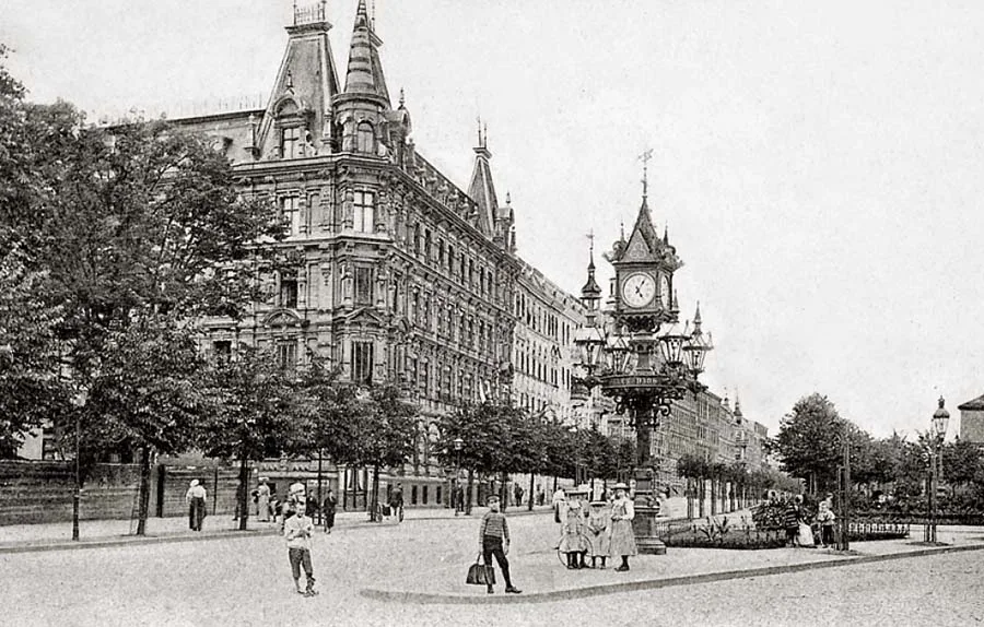 Street clock on Kaiserplatz.
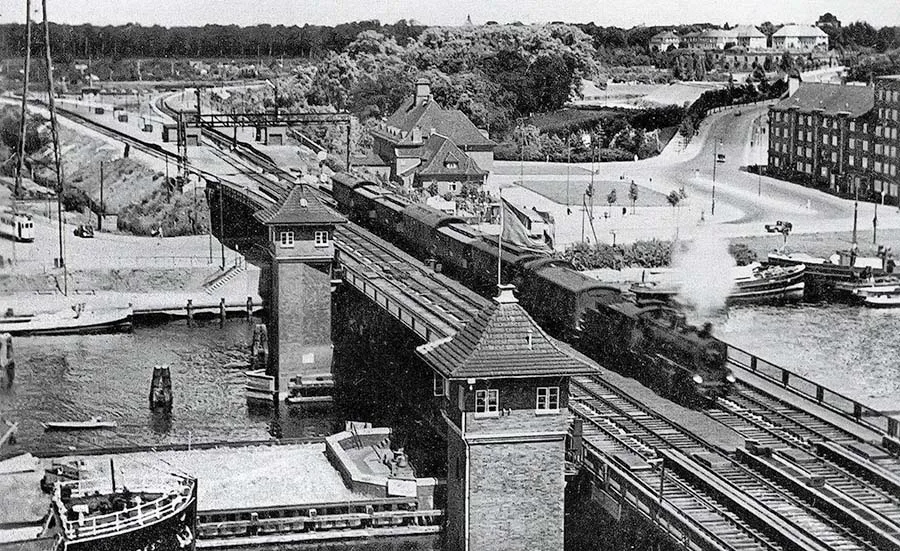 The railway bridge (Reichsbahnbrücke).
By 1860 the railway had been laid to the very east of the province, to Eydtkuhnen / Eydtkuhnen (Chernyshevskoye), where it joined the railway network of the Russian Empire. Thus the Eastern Station in the Vorstadt became Königsberg's main "railway gateway". For running rail traffic, the station had an extensive infrastructure in the form of a marshalling yard and depots with service sidings and turning loops. In 1863 the Southern Station (Südbahnhof) was opened next to the Eastern Station. It should not be confused with today's Southern Station of Kaliningrad, which was built later and before the war was called the Main Station (Hauptbahnhof). In 1862 it was decided to build a railway bridge to connect the Eastern Station with the northern part of the city, where construction of the railway to Pillau / Pillau (Baltiysk) had already begun. The bridge piers had been built by 1865, but the construction itself dragged on somewhat and was completed only by 1884. The first train crossed it on 1 October 1889.
The 19th century was not only the age of steam but also the age of lighting gas. It had been obtained earlier, in the production of charcoal, but at that time it brought charcoal burners nothing but trouble – lighting gas, a significant proportion of which was carbon monoxide, sometimes caused tragic incidents during charcoal production.
But later people learned to use it as fuel in gas lamps and domestic gas stoves. Unlike methane, lighting gas burned with a bright yellow flame of a spectrum pleasing to the eye. Industrial-scale gas consumption required industrial methods of production. Lighting gas was now obtained by coking coal, which is why it also came to be called coke gas, and the plants that produced it coke-gas works or simply gasworks. Such a gasworks was built in the Vorstadt on the Jahrmarkt-Platz. And although coke gas was less poisonous than gas from wood, it was not completely safe. Townspeople had to put up with periodic leaks from the works. But in those days no one yet raised questions about urban ecology and its effect on citizens' health. Residents were more worried by real stories, growing into urban legends, of accidental and deliberate poisonings by gas from stoves and lamps. Incidentally, it was only by 1964 that the share of coke gas in Germany's gas network fell below 50%, giving way to natural gas.
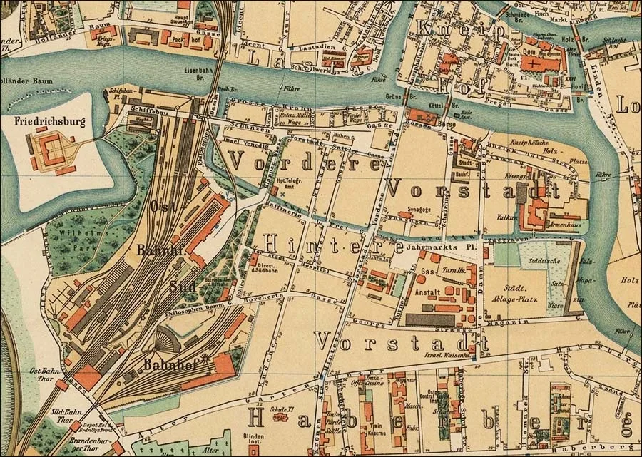 The Vorstadt on a map of Königsberg (1885).
In 1870 the old granaries on the bank of the Pregel were demolished, and by 1875 a new stock exchange building designed by the architect Heinrich Müller / Müller (1819–90) had been built on their site. Because of the marshy soil its construction involved a number of difficulties; in particular, 2,200 oak piles up to 18 m long had to be driven into the ground. The stock exchange building also housed Königsberg's chambers of commerce and of commerce and industry.
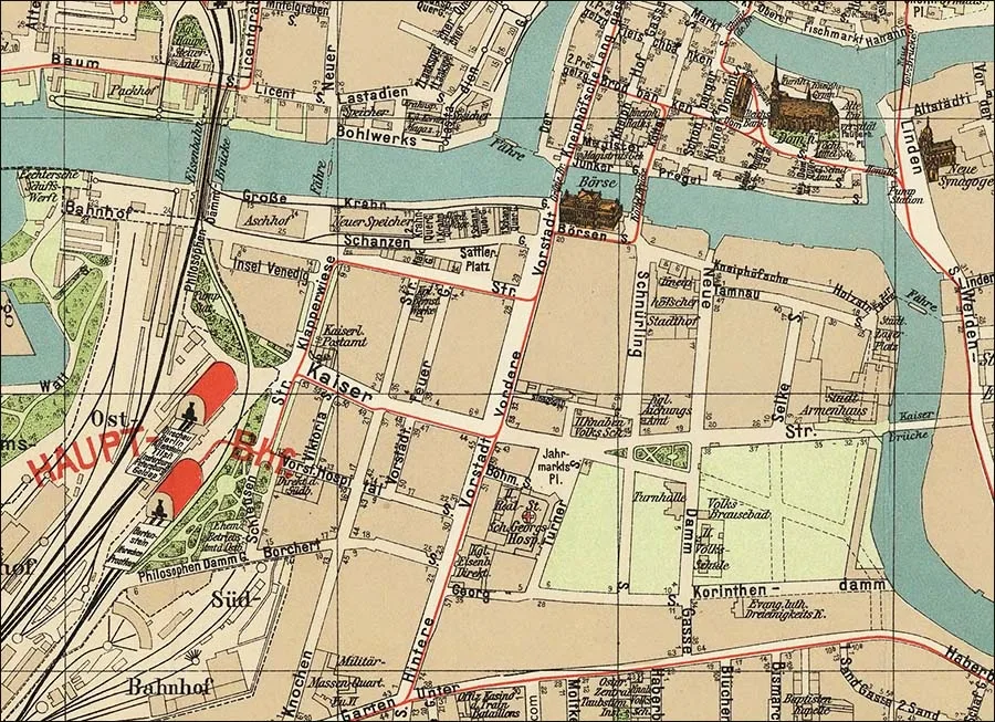 The Vorstadt on a map of Königsberg (1901).
In the last quarter of the 19th century, besides the buildings and institutions mentioned above, the Vorstadt was home to the directorates of the Southern and Eastern Stations, the Main Telegraph Administration and an almshouse. In 1893 the Orthodox Jews of Königsberg received permission to build a synagogue of their own, which was erected on the same Synagogen Gasse next to the existing synagogue. Orthodox Jews lived mainly in the Vorstadt and, unlike the liberal Jews who were most numerous in Königsberg, sought to preserve the traditions of the Jewish community as fully as possible and not to assimilate into Königsberg's public life. Incidentally, this was already the third synagogue in the Vorstadt: besides it and the so-called "old synagogue" mentioned above, there was also a synagogue of Hasidic Jews in this district, located at Vorstädtische Feuerstraße / Vorstädtische Feuerstraße 2 (its site is now occupied by a "Khrushchyovka" at Leninsky Prospekt 44–50). In addition, at Vorstädtische Langgasse 71a there was a school for Eastern (Polish) Jews, opened in 1865, which also served as a place for religious services.
After a new liberal synagogue was built on Lomse / Lomse Island (Oktyabrsky Island), the old synagogue was left to the Eastern (Polish) Jews, who also lived for the most part in the Vorstadt.
In 1894–97 the Hospital of St George was completely rebuilt. Its new buildings no longer had anything in common with the ancient structure of 1329, since the hospital had burned down at least six times since then, each time being rebuilt in altered form. The new design in the Neo-Gothic style was drawn up by the municipal master builder Karl Worms / Worms (1858–1912). The completed complex, with its two easily recognisable towers, became one of the most remarkable buildings of the Vorstadt and remains so in modern Kaliningrad.
In 1899, at the corner of Sattlergasse / Sattlergasse (part of Portovaya Street) and Knochenstraße / Knochenstraße (Serpukhovskaya Street), the three-storey building of the Amber Manufactory was built. After the entrepreneur Becker had created mechanised amber mining in Palmnicken / Palmnicken (Yantarny), and the operation was then bought out by the state when the lease on the plot expired, the question arose of creating a local enterprise to process the raw amber. Mined amber was now relatively cheap, and the volume of extraction was considerable.
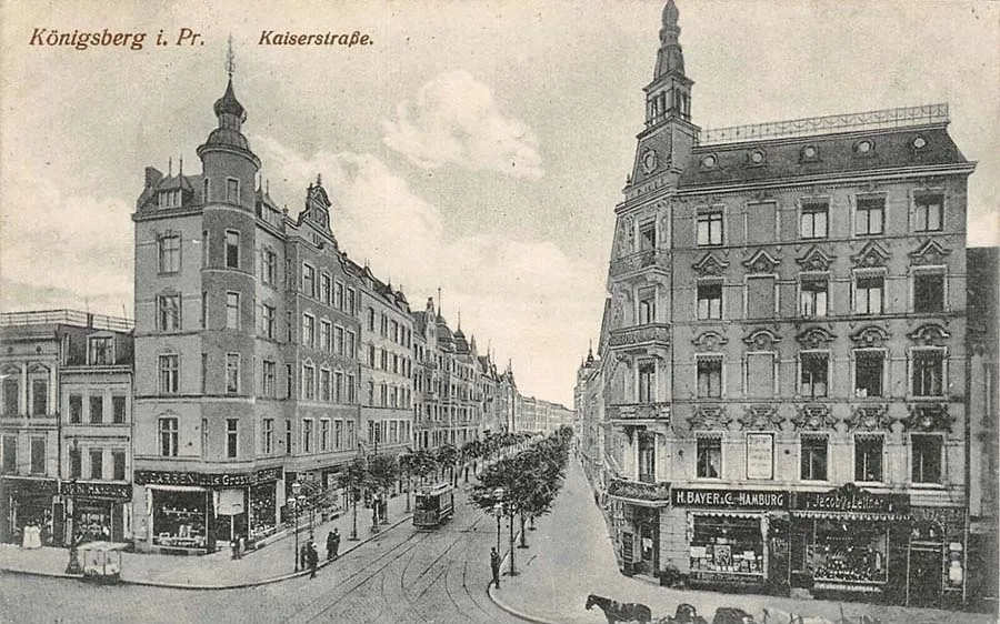 Kaiserstraße – once a canal, now a street (Krasnooktyabrskaya).
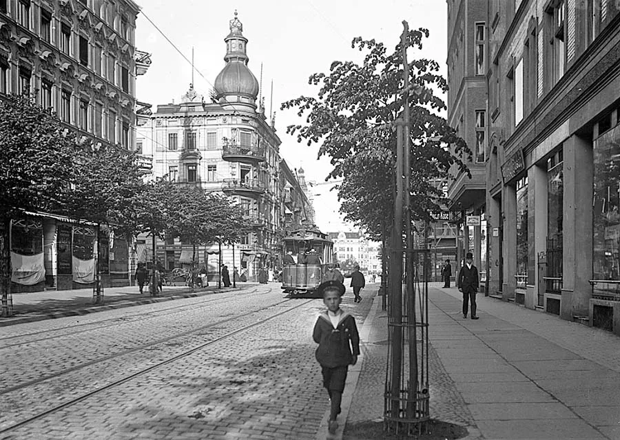
Processing amber increased its value many times over, even by orders of magnitude, and was therefore profitable for the city. The manufactory employed 200 workers, 14 managers and several inspectors. In addition, some 400 women homeworkers were attached to it (working amber at home was traditionally considered a women's craft in Prussia).
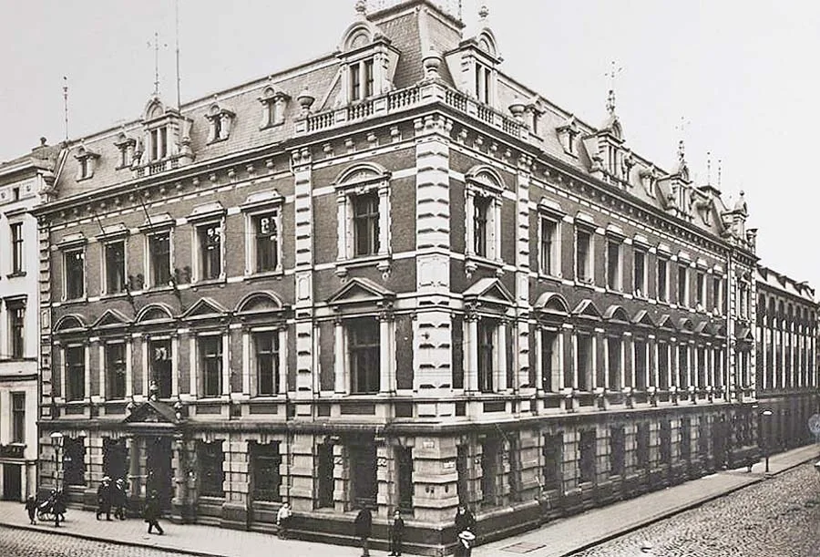 The Amber Manufactory (Bernsteinmanufaktur).
At the turn of the 19th and 20th centuries the first and only Lutheran church in the Vorstadt appeared – the Trinity Church / Dreieinigkeits Kirche. The building was small, stood on Korinthendamm / Korinthendamm (Professora Morozova Street) and has not survived to our day. It seems that photographs of this church have been lost as well. But judging by aerial photographs, it was a simple building without a tower or the elements typical of places of worship.
In 1905 the Zuggraben canal was completely filled in, and in its place Kaiserstraße / Kaiserstraße (Krasnooktyabrskaya Street) was laid out, which became the second-largest and second most important street of the Vorstadt after Vorstädtische Langgasse. On the eastern side the street ended at the Imperial Bridge (Kaiser-Brücke / Kaiser-Brücke) over the Pregel. Its site is now occupied by the Jubilee Bridge, which outwardly reproduces the Imperial one.
In 1910–11 the bastions of Fort Friedrichsburg were levelled. Although it formally lay outside the boundaries of the Vorstadt, this event in the history of the district cannot go unmentioned. Today a bastion fort of regular geometric shape could probably have become a popular tourist attraction, but at the time its existence within the city was considered inappropriate.
We can only thank the city authorities of Königsberg for leaving us at least its entrance gate. This gate, built in 1852, is now the oldest architectural monument in the southern part of the city.
In 1914, in the block formed by Neue Dammgasse / Neue Dammgasse (Novy Val), Korinthendamm / Korinthendamm (Professora Morozova Street) and Selkestraße / Selkestraße (Maly Pereulok), a vocational training institution was opened that united the commercial school and the higher commercial school, as well as a number of other vocational schools. It was later turned into a further-training school.
General schooling in the Vorstadt was represented by an elementary school for girls and an elementary school for boys (both buildings have survived and are now on the grounds of the Marine College) and a higher school for girls. There was also a Realgymnasium, but it later became part of the vocational training school. On Neue Dammgasse there was also a gymnasium hall (its site is now occupied by a five-storey block at Novy Val 18–24), and across the road from it there were public showers.
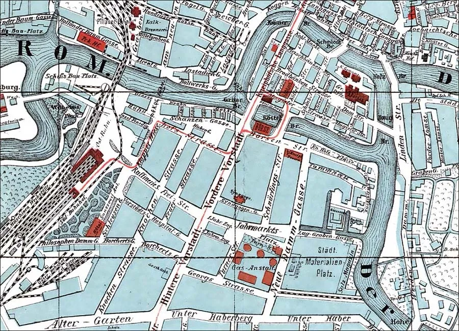 The Vorstadt on a map of Königsberg (1913).
In 1926–27, near the Pregel on Michellystraße / Michellystraße (part of Epronovskaya Street), a telegraph building designed by the architect Kurt Frick / Frick (1884–1963) was built, and in 1926–28, on Selkestraße, the building of the "Pregel" telephone call office, designed by the same architect.
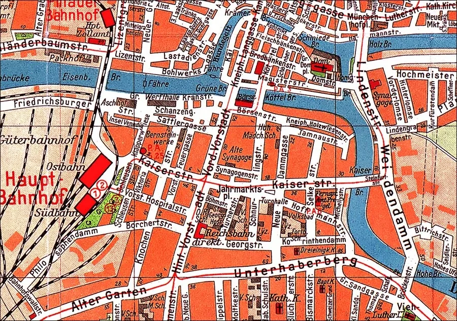 The Vorstadt on a map of Königsberg (1928).
This building was adorned with the sculptural portal "Communication by Telephone" by the artist Franz Andreas Threyne / Threyne (1888–1965). At that time call offices were in great demand, since when the "Pregel" office opened there were only 11,000 telephones in Königsberg. That is, fewer than 10% of offices and households had a telephone, and such call offices were the only place from which most citizens could contact subscribers in other cities of the country.
After the Nazis came to power, on the night of 9 to 10 November 1938, mass pogroms against Jews took place in Königsberg, which went down in history as "Kristallnacht". Naturally, the synagogues of the Vorstadt were also targeted. After being ransacked, the buildings were set on fire. Only the Orthodox synagogue escaped burning, because it stood close to other houses and a fire in it could have spread to the whole district.
On 30 August 1944, during the second (and best-known) bombing of Königsberg by the Royal Air Force, incendiary and some high-explosive bombs fell on the Vorstadt. The district was engulfed by the resulting fire, although the density of the bombing here was apparently lower than in neighbouring Kneiphof.
It also mattered that residential buildings here were interspersed with industrial facilities, the streets were fairly wide, and the buildings themselves were younger than those of Kneiphof or Altstadt and so contained fewer wooden elements. As a result, many buildings survived, although they were damaged by fire. Only in the eastern and south-eastern parts of the Vorstadt did almost all the buildings keep their roofs. But seven months later the Vorstadt found itself in the attack sector of the most battle-ready 11th Guards Army. This time tonnes of artillery shells rained down on the quarters of the Vorstadt, while from above ground-attack aircraft and front-line bombers showered the district with bombs, aircraft cannon shells and rockets.
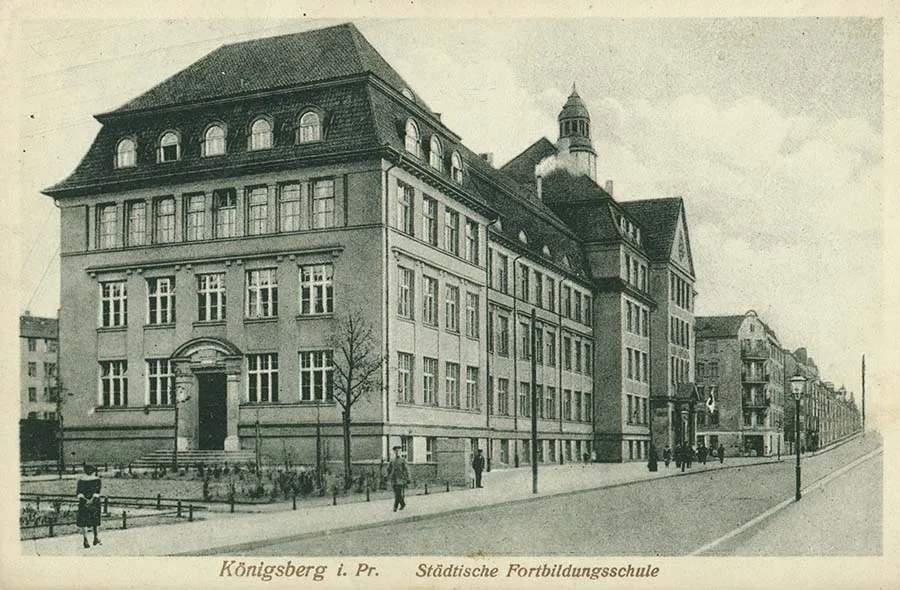
The New School for the further training of teachers (Neue Fortbildungsschule).
After the fighting ended, the Vorstadt district was a sad sight – which, however, was characteristic of the whole of Königsberg inside the ring of ramparts.
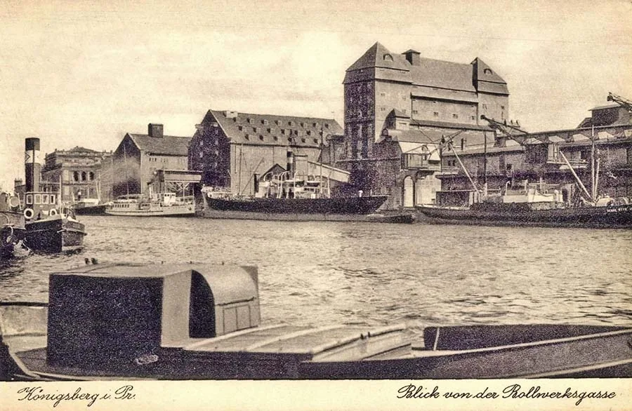 The face of the Vorstadt – the Great Cranes Embankment (Grosse Krahn Gasse). The Stock Exchange is visible on the left.
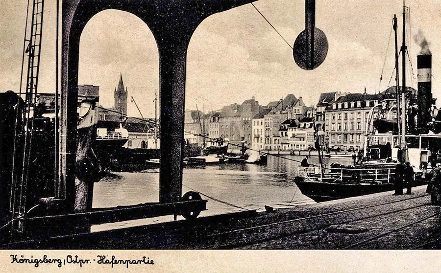 View from the Great Cranes Embankment of the Pregel. On the left, the castle tower adorns the Königsberg skyline. On the right, beyond the Hundegatt, is the Kneiphof embankment, the Kai.
For the ruins of the Vorstadt the standard decision was taken: the sturdiest administrative buildings were to be restored, while the housing stock, which had been built with a smaller safety margin, was as a rule dismantled for building materials, which were used, among other things, to restore and rebuild those Königsberg buildings for which such work was deemed expedient.
By 1955 the ruins had largely been cleared, and the Vorstadt now looked like a huge wasteland with pre-war buildings slated for restoration sticking up here and there. Among the first to be restored were the Amber Manufactory building (in 1952) and the Hospital of St George (c. 1955).
The main work on building houses on both sides of Leninsky Prospekt was carried out in 1963–64, after which development began along the other streets. In addition, the port administration restored the railway directorate building (Leninsky Prospekt 111–117) to house its employees. In 1967 work began on restoring the Stock Exchange building.
The restored building lost many decorative elements, yet today it is a true ornament of the city. But these were only isolated instances of recreating German architecture – by the early 1970s the main type of building in the district had become the 4–5-storey houses of the late Stalin period and "Khrushchyovkas".
By the 1970s the former Vorstadt had become one of the liveliest districts of the city. Tram routes No. 2 and No. 3 (Leninsky Prospekt) and No. 7, No. 8 and No. 10 (Bagrationa Street) ran along its streets. Here were institutions as important to townspeople as the Kaliningrad Nautical School (KMU) in the buildings of the former Hospital of St George, the Kaliningrad Technical Institute (KTI, Maly Pereulok 32), the Sailors' Palace of Culture (in the former Stock Exchange building), the popular Atlantika restaurant (Leninsky Prospekt 42b), the city cosmetology clinic (Serpukhovskaya 7), and the shops "Detsky Mir" (Leninsky Prospekt 83b), "Melodiya" (Leninsky Prospekt 36), "Rubin" (Leninsky Prospekt 42), "Knigi" (Leninsky Prospekt 107), "Bashmachok" (Leninsky Prospekt 86), "Khudozhestvenny Salon" (Bagrationa 116) and "Uchebnye Posobiya" (Bagrationa 100).
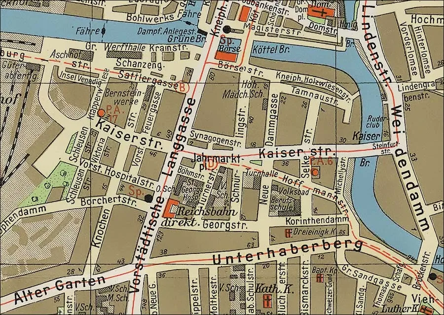 The Vorstadt on a map of Königsberg (1938).
The 1990s and the first decade of the 21st century hardly affected the territory of the former Vorstadt. Several high-rise apartment blocks were erected, which still look like foreign bodies in this district.
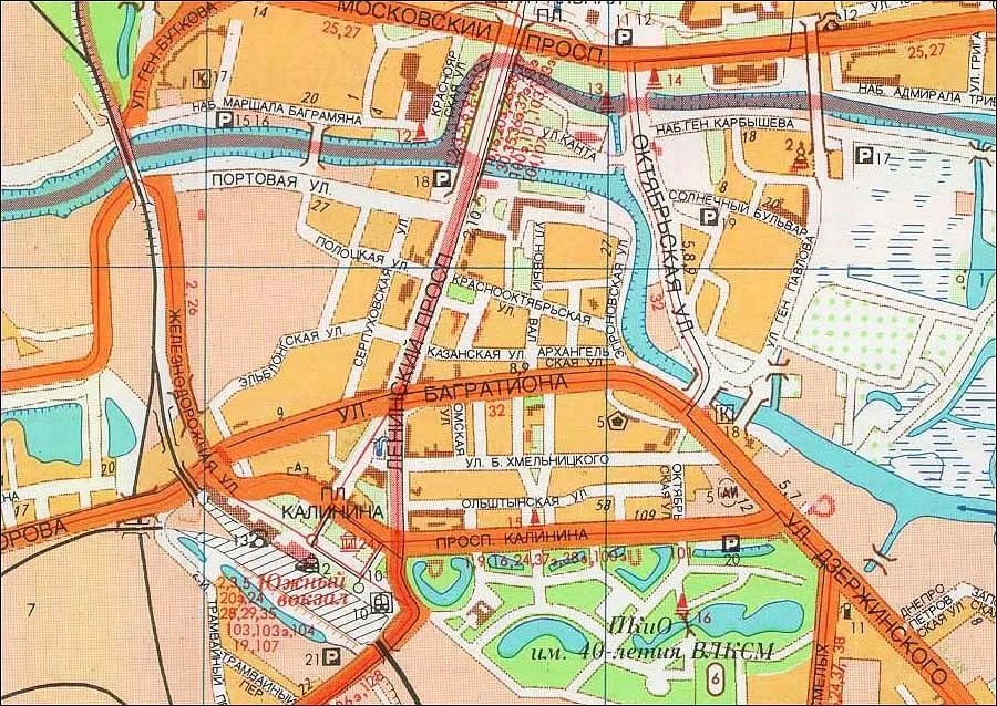 The Vorstadt area on a map of Kaliningrad (1992).
Shops that had been landmarks of the Soviet period closed. The Sailors' Palace of Culture in the Stock Exchange building was turned into the Regional Youth Culture Centre. Trams stopped running along Leninsky Prospekt; the rails here remained only for service traffic. The most important events of the 21st century for the Vorstadt were the opening of a branch of the Museum of the World Ocean (2011) in the restored gate of Fort Friedrichsburg. Also, in 2018, in the run-up to the FIFA World Cup, the Exchange Square with a light-and-music fountain was opened next to the Stock Exchange building. However, the regional administration very quickly thought better of it and renamed the square the Square of the 70th Anniversary of the Kaliningrad Region, although public polls favoured the first name.
At the same time, in 2018, the Kaliningrad Regional Museum of Fine Arts moved into the former Stock Exchange building.
Today [July 2024], 27 pre-war buildings have survived in one form or another in the former Vorstadt. Of these, special mention should be made of those already referred to in this article: the Stock Exchange (Leninsky Prospekt 83), the Hospital of St George (Morekhodnaya Street 3), the Amber Manufactory (Serpukhovskaya Street 1), the Directorate of the Imperial Railways (Leninsky Prospekt 111–117), the Further-Training School (Maly Pereulok 32), the "Pregel" telephone call office (Maly Pereulok 17) and the Telegraph (Epronovskaya Street 15a–17). Also restored are the buildings of the Shoe Factory (Epronovskaya Street 31), the School for Girls and the School for Boys (Morekhodnaya Street 3), the Royal Yacht Club (Portovaya Street 18, building 1) and the Fire Service garage (Portovaya Street 18).
– – – – – – – – –
The "Vorstadt" chapter
from the book by local authors "Königsberg Local Studies",
published at the end of the 19th century
In 2012–2014, "Pregola", the literary supplement to the "Baltic Almanac",
published a translation of the book by the Königsberg authors Dr Richard Armstedt, professor at the Altstadt Gymnasium, and Dr Richard Fischer, senior teacher at the Kneiphof Gymnasium, "Königsberg Local Studies" ("Heimatkunde von Königsberg i. Pr.", 1895, Kommissionsverlag von Wilhelm Koch, Königsberg), made by an unknown translator. The idea of publishing it belonged to Igor Vladimirovich Afonin. The text was adapted and annotated by Aleksey Borisovich Gubin and Igor Fyodorovich Avtukhov. That book had a separate chapter on the Vorstadt. Having edited it substantially, we present it to you as a supplement to the text by
Aleksey Yevgenyevich Petrushin.
– – – – – – – – –
Vorstadt
THE FRONT VORSTADT
The southern bank of the Pregel (Pregel) has belonged to Kneiphof (Kneiphof) since ancient times. The suburb nearest to it is called the Inner or Front Vorstadt (Innere oder Vordere Vorstadt). The Front Vorstadt is connected with Kneiphof by the Green and Giblets Bridges (Grüne- und Köttelbrücke), and with the Altstadt port and warehouse district of Lastadie (Lastadie) by the Railway Bridge (Eisenbahnbrücke). The southern boundary of the Front Vorstadt is Imperial Street (Kaiser Straße, today Krasnooktyabrskaya and Polotskaya Streets). Where this street now runs, partly built up with splendid modern buildings, the murky water of the Encircling Moat (Zuggraben) stood not so long ago; beginning at the Salt Meadow (Städtische Salz-Wiese) and flowing back into the Pregel at the Railway Bridge, it cut off the Front Vorstadt, effectively turning it into an island.
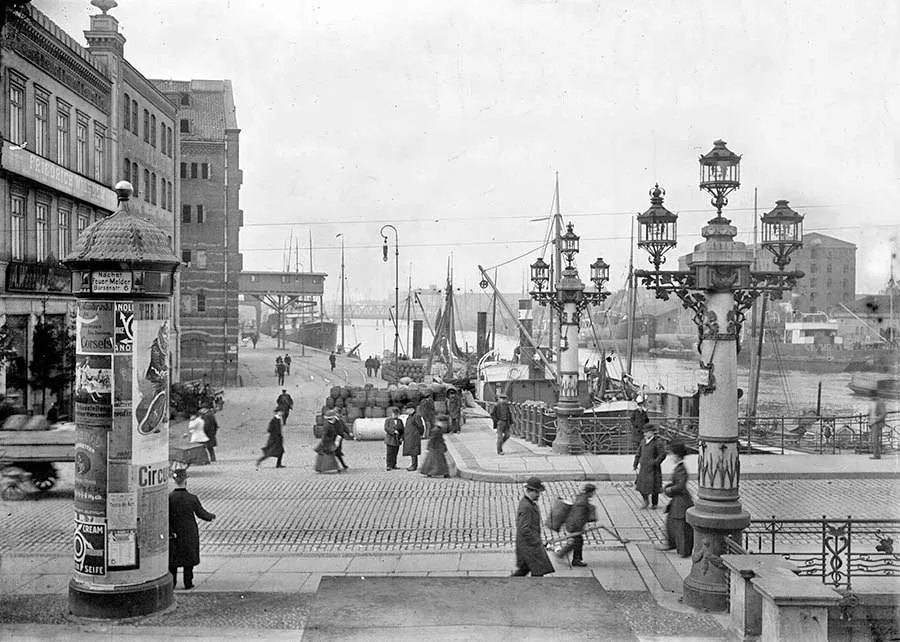 View of the Great Crane Embankment, which for some reason the authors do not mention. On the right is the Green Bridge.
In 1520, when there was a danger of attack by the Poles, the people of Kneiphof dug the Encircling Moat, threw up a dam and built a bridge over the moat (Zugbrücke) connecting the Front Vorstadt with the Rear Vorstadt, the passage into which was protected by a solid gate.
Imperial Street, which received its name this year (1895), replaced the lanes that in former times ran along the Encircling Moat. Thus, in the part adjoining the Eastern Station there was Sugar Lane (Raffineriestraße), because a sugar refinery (Zuckerraffinerie) had once stood here. The eastern continuation of this lane was called Freystraße (Freystraße) – after the Privy War Councillor and Government Director Johann Gottfried Frey (Johann Gottfried Frey, 1762–1831). This official played an outstanding role in drafting the Prussian municipal code introduced in 1808.
Adjoining Imperial Street is the Fair Square (Jahrmarktsplatz), which formerly lay on the bank of the Encircling Moat and took in the grounds of the Gasworks (Städtischen Gasanstalt) and the adjoining sports complex (Turnanstalt). Now the name refers only to a small part west of the Gasworks and north of Gymnastics Street (Turnen Straße).
(The gasworks was founded in 1852. After a new one was built in 1900–1902 in the Cosse area, the old one was dismantled. It occupied an area along Krasnooktyabrskaya Street roughly corresponding to that on which the Kaliningrad Marine Fisheries College now stands; the former Gymnastics Street was located there too – Editor's note.)
The main street of the Front Vorstadt used to be called Straight Street (Gerade Straße). Now it is called Vorstadt Street (Vordere Vorstadt) and runs from the Green Bridge southwards to the former bridge over the likewise former Encircling Moat. (Judging by maps of Königsberg from various years, the main street bore the name Vordere Vorstadt from 1677, and from about the 1930s it came to be called Vorstädtische Langgasse (Vorstädtische Langgasse). Today it is Leninsky Prospekt – editor's note.)
In 1329 the Teutonic Order, which had grain stores on the site of the present Front Vorstadt, ceded this territory to the town of Kneiphof in exchange for a supply of two tonnes of wine, so that a Lastadie (Lastadie, a trading port) could be set up here.
Later the territory received the status of a freedom (Freiheit) and had its own court and seal. The seal showed a hand emerging from clouds and holding the scales of justice, with two hunting horns on either side of the hand. The Front Vorstadt freedom existed until 1724.
This part of Kneiphof burned many times. The most severe fire occurred in 1550 and destroyed about a hundred houses. Also burned was St Anthony's Hospital (St. Antonienhospital), built in 1502 not far from the bridge over the Encircling Moat and dedicated to the Virgin Mary and St Anthony. This hospital was never rebuilt, and all its surviving property was handed over to the Cathedral (Domkirche). The next great fire raged in the Vorstadt on 25 May 1769, when no fewer than 76 dwelling houses and 143 grain stores burned down. The total damage amounted to 150,000 thalers.
The last great fire occurred on 14 June 1811. It began in a Kneiphof warehouse used for storing herring. Within half an hour all the warehouses in the west of the Front Vorstadt were ablaze. The Pregel on this stretch was literally jammed with rafts (wittinen), which soon caught fire too. The river was a sea of flames. All the houses and warehouses burned down; the streets were gone. With great difficulty the Green Bridge, the Green Gate (Grüne Thor) and the stock exchange were saved, so that the flames did not spread to Kneiphof. 114 houses, 134 warehouses, 1,620,000 scheffels of grain, four thousand barrels of wine and a countless quantity of other goods were burned. The damage amounted to about 13 million thalers. As a result of so devastating a fire, the architecture of the stricken freedom naturally changed substantially – it acquired its present appearance. The charred remains of buildings were used to compact the soil and to build up a dam. For a long time afterwards the "Million Dam" or "Dam of Tears" (Millionendamm oder Thränendamm) was on everyone's lips in the city, as a reminder of that catastrophic fire and its colossal losses.
Not far from the Green Bridge, right on the bank of the Pregel, the building of the new stock exchange catches the eye; it occupies almost the entire space between the Green and Giblets Bridges. It stands where a cab rank and a guardhouse used to be. The stock exchange was built in 1870–1875 (architect Heinrich Müller (Heinrich Müller, 1819–1890), who also designed, among other things, the stock exchange in Bremen – editor's note) on the commission of the corporation of Königsberg merchants and opened on 6 March 1875. This magnificent building stands on 2,202 piles 12–18 metres long.
The Königsberg Stock Exchange is built of sandstone in a noble Renaissance style. The four corners of the building are adorned with the sculptural groups "Europe", "Asia", "Africa" and "America", intended to symbolise the nature of trade as something that binds countries and peoples together.
The sculptures were made by the Berlin sculptor Emil Hundrieser (Emil Hundrieser, 1846–1911), a native of Königsberg. The main building of the stock exchange is 73 metres long and 23 wide. On the north side it is adjoined by an annex of equal length, 12 metres wide.
The main entrance to the stock exchange is on the western side of the façade. It is approached by a magnificent staircase, on either side of which two lions sit on pedestals: one holds the city's coat of arms, the other the arms of the merchant body. Passing through the vestibule, we enter the beautiful Exchange Hall (Börsensaale). It is 23 metres long and 19 high. The hall is surrounded by a gallery with a double row of columns. In size this hall of the stock exchange ranks second in Königsberg after the Muscovite Hall (Moskowitersaale) in the castle. Here every day except Sunday and Friday, between half past eleven and half past one in the afternoon (the so-called exchange hours / Börsenzeit), merchants gather to conclude deals and set the prices of goods. Besides trading operations, the exchange hall is used for balls, concerts and other public events.
Next to the Exchange Hall is the Summer Exchange (Sommerbörse). It can be entered through three double doors. The Summer Exchange adjoins the main building on the river side and is lit through a glass roof. This room is also sometimes rented out for various purposes. Recently the local art association has been holding ceremonial exhibition openings here every two years.
In front of the eastern façade of the stock exchange there is a large platform from which one reaches the massive interior flights of stairs. Here, among other service rooms, is the main office of the Board of Directors of the local Chamber of Commerce (Gescshäftsräume des Vorsteheramtes der Kaufmannschaft). Here too are the Imperial Telegraph Office (Kaiserliches Telegraphenamt) and the entrance to the gallery of the Exchange Hall. On the ground floor is the entrance to the restaurant "Börsentunnel" (Börsentunnel, i.e. Exchange Tunnel). The rooms facing Exchange Street (Börsenstraße) are rented to the Imperial Post Office (Kaiserlichen Postamt). The cost of the entire structure was approximately two million marks. (The trade exchange building was damaged during the war and restored in simplified form in 1973 as the Sailors' Palace of Culture on Leninsky Prospekt; it now houses the Kaliningrad Regional Museum of Fine Arts – editor's note.)
South of the stock exchange runs Exchange Street; its eastern continuation is Kneiphof Wood Street (Kneiphöfische Holzstraße), which was formerly Kneiphof Watering Lane (Kneiphöfische Tränkgasse, now the Staropregolskaya Embankment).
Between the main traffic artery of the Vorstadt and New Dam Lane (Neue Damm Gasse) we find Schnürling Lane (Schnürlings Gasse, now Parusnaya Street). The story of its name is as follows: two sons of the Kneiphof burgomaster Hans Schnürling (Hans Schnürling, gest. 1581), who governed the town in the second half of the 16th century, leased the local meadows and founded a dairy farm. The lane, which bore the burgomaster's surname, like most of the Vorstadt streets became passable only after they had built a dam here. Along the lane ran a ditch that drained water from the Encircling Moat back into the Pregel. Both the dam and the ditch were named after the glorious Schnürling family (Schnürlings Damm und Schnürlingsgraben).
From the corner of Schnürling Lane and Exchange Street up to its junction with New Dam Lane stands a complex of buildings belonging to the municipality of Kneiphof. These are the Municipal Building Yard (Stadtbauhof), used to store equipment, machinery and building materials, and the Kneiphof Town Yard (Kneiphöfsche Stadthof), which is the base of the fire brigade and houses the fire station with stables and everything needed for street cleaning. All of this has been here since the beginning of the 17th century. Only the name has changed – the Building Yard was formerly the Carpenters' Yard (Kneiphöfsche Zimmerhof), as yards of this kind were called at the time.
The area east of New Dam Lane used to consist almost entirely of so-called "wood meadows" (Holzplätze), and even now large areas here are used for storing firewood. But the vigorous building activity of recent years has begun to transform the district. Whole new streets have been laid out here. For example, Tamnau Street, running from New Dam Lane at right angles towards the Pregel. This street is named after the chairman of the city council, Privy Commercial Councillor Tamnau (Johann Daniel Tamnau, 1777–1860), who owned a plot of land here. Now house No. 22 on the street bearing his name is the almshouse (Städtische Armenhaus; possible translations: house of charity or, more plainly still, shelter for the poor – editor's note). Originally, from 1691, it housed a prison. After the prison was moved to Ragnit (now the town of Neman) in 1830, the building was turned over to the shelter. The number of paupers living in it reaches 148; they earn their bread by chopping firewood for municipal institutions, helping with housework, making oakum and doing other similar work that requires no special knowledge or training.
South of Exchange Street and parallel to it runs Synagogue Lane (Synagogen Gasse), where house No. 2 is the predecessor of the new synagogue. It was built in 1815 on the site of the earlier synagogue built in 1756.
The residence of Jews in Prussia was very strictly regulated until the 17th century. At times they were refused the right to live there at all. The Jewish community received permission to build a synagogue from the Great Elector in 1680.
For this purpose the house of Count Eulenburg (Friedrich Albrecht Graf zu Eulenburg, 1815–1881) was rented – today the hotel "Deutsches Haus" (Deutsches Haus) in Dead-End Lane (Kehrwiedergasse), now Teatralnaya Street (Theater Straße). For more than 20 years after that the Jews still had no right to establish a cemetery of their own in Königsberg and buried their dead near the Polish border, that is, 30 miles from the city. Only in 1703 did the Jews receive permission to buy land for a cemetery in Tragheim (Tragheim). The street on which it arose came to be called Jewish Cemetery Street (Judenkirchhofstraße), later Wrangelstraße (Wrangelstraße, now Chernyakhovskogo Street). The new Jewish cemetery lies beyond the Lithuanian Rampart (Litthauer Wall) between the King's and Rossgarten Gates (Königs- und Rossgärter Tor. In connection with the restoration of the gravestone of the well-known preacher Israel Salanter (1810–1883), the territory of this cemetery was fenced off in the 1990s, and work to put it in order continues in the 2020s – editor's note)
The second synagogue also stands in Synagogue Lane. Its congregation split from the main Jewish community in 1870 and built its synagogue in 1893. This community bears the name "Adass Yisroel" (Adats Isroel, meaning Community of Israel); its adherents observe all religious precepts very strictly. Before building their synagogue, the followers of the new movement rented premises for worship. (The former Synagogue Lane no longer exists. It lay north of Krasnooktyabrskaya Street between Leninsky Prospekt and Parusnaya Street – editor's note.)
Until the beginning of the 19th century the Jews in Königsberg were deprived of all political rights. They were admitted to trade and crafts only with great restrictions. Only in 1808 did the Jews receive equal rights with the other estates. In 1802 the Jewish population of Königsberg numbered 854 people, that is, 0.6% of the city's entire population, which then stood at 50,000. The general census of 1890 recorded that the number of Jews in Königsberg had grown to 4,000, which was already 2.5% of the city's entire population.
In Synagogue Lane, in houses No. 7, 8 and 10, is the Royal Building Trades School (Königliche Baugewerkschule), founded in 1892. It is a vocational school teaching the following: 1. The first skills of building, a theoretical foundation on which students can then develop their knowledge. 2. The use of building resources, the ability to choose a building site, conducting negotiations, managing the entire construction process. 3. The training of technical staff of various levels and profiles. The school is under the authority of the Royal Administration. It has four classes, and the course of study lasts half a year. Also subordinate to the Royal Administration is the Royal Provincial School of Arts and Crafts (Königliche Provinzial-Kunst- und Gewerkschule) at Magisterstraße 55. This school teaches the rudiments of drawing to future craftsmen. It was founded in 1790 and was originally called the School of Art and Drawing (Kunst- und Zeichenschule). It has been reorganised several times, most recently in 1855. A new combined building school is now planned at Tragheim Powder Street 17 (Tragheimer Pulverstraße). (The school was indeed built in 1897 at the corner of Tragheimer Pulverstraße and the new Schönstraße; the building's address today is Generala Sommera Street 27 – editor's note.)
The first street running parallel to the main street of the Vorstadt on its west side is called Bone Street (Knochen Straße, now Serpukhovskaya Street). The bridge of the same name on it (Knochen brücke), before the Encircling Canal was filled in, connected the Front Vorstadt with the Rear Vorstadt.
Where Bone Street now crosses Imperial Street stands Grosskopf's tobacco factory (Großkopfsche Tabaksfabrik).
West of Bone Street and parallel to it, where there used to be a meadow on which oak boards for making barrels (Klappholz) were stored, an elegant new street, Storage Meadow (Klapperwiese; it is still called Skladskaya – editor's note), has now been laid out.
We can get some idea of the charms of the local landscape from the name of the lane Venice Island (Insel Venedig – yes, that really was its name until the fateful 1940s). Once this part of the Vorstadt really was a little island amid the local quagmires.
The present Station Street (Bahnhofstraße), which runs parallel to the Pregel and meets Vorstadt Street at right angles from the west – or rather its eastern part up to Storage Meadow – used to be Saddlers' Lane (Vorstädtische Sattler Gasse), where the house in which Immanuel Kant was born stood. Here is the amber museum of the firm "Stantien & Becker" (Bernsteinmuseum der Firma Stantien & Becker. Today this is the eastern part of Portovaya Street, where that building has survived, now better known as the "Amber Manufactory". In the mid-2020s, although it could undoubtedly be an ornament of the district, it still stands abandoned – editor's note.)
If we go out onto the bank of the Pregel in the eastern part of the Vorstadt, we find ourselves in the warehouse quarter of Kneiphof, that is, in the former Kneiphof Lastadie (Kneiphöfische Lastadie). Ships are being loaded and unloaded at the quays. On the opposite bank the same bustle reigns in the Altstadt Lastadie. Here one notices numerous former weighing houses (Vorder-, Mittel-, Ostliche und Westliche Hinterwage). Now they are rented out as warehouses. Nearby, after the fire of 1887, the Ash Yard (Aschhof) was rebuilt. In former times, when ash was still an important commodity in Königsberg, it served as an inspection post. The offices and services that dealt with trade wagons and such inspection posts were called fiefs, and the officials who worked in them vassals. The weighmasters were among them too. This terminology goes back to the times when townspeople still had the right to bear arms, and these posts were granted by the town council only in exchange for military service.
In its southern part Storage Street comes out onto Station Square (Bahnhofsplatz) in front of the Eastern and Southern Stations (Ost- und Südbahnhof). This whole area, where the stations now stand, was only a few decades ago a marshy expanse. It was bounded by a dam planted with willows, called the Philosophers' Dam or Philosophers' Walk (Philosophendamm oder Philosophengang). To build it, colossal quantities of rubbish and ash left by the fire of 1811, so catastrophic for the Vorstadt, were used. That is why, as noted above, the Philosophers' Dam was unofficially called the "Dam of Tears" in the city.
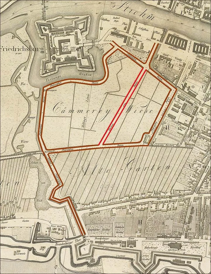
The Philosophers' Dam on a map of 1815. The Dam of Tears is marked in red.
The version that it supposedly got its name because the shady path along it was Immanuel Kant's favourite place for walks finds no confirmation. The fact is that the dam received its name long before the famous philosopher was born.
(Indeed, according to the data given by G. Karl, the place name Philosophers' Meadow (Philosophenwiese) appeared as early as 1648 – ed.) On the city map of 1815 the Philosophers' Dam encircles the entire Vorstadt marsh, winding from Fort Friedrichsburg in the north to Old Garden Street (Alter Garten, now the western part of Bagrationa Street) in the south, where it then reached the Brandenburg Gate (Brandenburger Thor). After the marsh enclosed by the Philosophers' Dam was drained and the stations were built, two fragments of the dam remained: in the south, a lane leading to the roundhouse at the Southern Station; in the north, a section of the eastern bank of the former Encircling Moat in front of the Railway Bridge.
Opposite the north wing of the Eastern Station, near the water tower, is the observation station of the Royal Prussian Meteorological Institute (Beobachtungsstation des Königlich preußischen meteorologischen Institutus). In Berlin, weather observations had been carried out since 1827 at the local observatory. In 1887 Königsberg acquired its own weather station under a specially appointed official; it was originally located in the Botanical Garden (Botanischen Garten) in Neurossgarten (Neuroßgarten), and since 1889 in its present building.
North-west of the station buildings, right by the Pregel and surrounded by wide moats, stands Fort Friedrichsburg. It was founded in 1657 by the Great Elector (Großer Kurfürst Friedrich Wilhelm, 1620–1688) to intimidate the rebellious inhabitants of Kneiphof. In 1671 a small church was built on its grounds, which served as the garrison church until 1816. Later the castle church was used for military services. The Friedrichsburg fortress, surrounded by earthen ramparts, forms a quadrangle. Until 1825 the fort was used as a military and civil prison. Here, in 1780–1781, as a young lieutenant, the future famous Field Marshal Yorck (Johann David Ludwig Graf Yorck von Wartenburg, 1759–1830) served a one-year sentence imposed on him by Frederick the Great (Friedrich der Große, 1712–1786). In 1852, in accordance with the modern requirements of fortification, walls and a handsome gate adorned with four towers were built. Today the fort is used for storing military property.
THE REAR VORSTADT
The Rear Vorstadt (Hintere Vorstadt) comprises the territory between the Encircling Moat in the north, the districts of Haberberg and Alter Garten (Haberberg und Alter Garten) in the south, the Old Pregel (Alter Pregel) in the east, and the stations with their approach tracks in the west.
The main street of the present-day Rear Vorstadt is Vorstadt Street (Hintere Vorstadt), which continues across its territory. It ends at the crossroads with Old Garden Street (Alter Garten) and Unter Haberberg (Unter Haberberg, both now parts of Bagrationa Street). Parallel to Vorstadt Street, New Dam Lane (Neue Damm Gasse, now the southern part of Novy Val Street) runs to the east, and Bone Street (Knochen Straße, now Serpukhovskaya Street) to the west.
As late as the middle of the 19th century most of the area of this Kneiphof suburb was taken up by a meadow, at the centre of which was a manor farm (Vorwerk) founded back in the days of the Teutonic Order. On that farm lived a field warden (Karwan- oder Kandisherr, which translates as "commander of an outpost" or "cabbage lord" – editor's note.)
We shall begin our journey through this part of the city at the salt warehouse (Salzmagazin) on the bank of the Pregel. The warehouse is a long, narrow building on the former New Dam (Neuen Damm) and is royal property.
To this day it serves for storing large stocks of salt. To the west of it lies the Salt Meadow (Salzwiese), used for storing not only salt but also building materials.
Among the buildings forming the western boundary of the Salt Meadow, worthy of mention are the Municipal Public Showers (Städtische Volksbrausebad), opened in 1895. This establishment was created specially for the poor, who can enjoy a shower and a warm bath here for a tiny fee.
New Dam Lane runs south from the Pregel, crosses the Encircling Moat and continues beyond it. The New Dam, after which the lane is named, used to be called the Million Dam (Millionendamm). In building it, what was left of the Vorstadt after the fire of 1769, which caused losses running into millions, was used. On the west this street is adjoined by a landscaped triangular square formerly called the Fair Square (Jahrmarktsplatz; now the public garden in front of the building of the Kaliningrad Marine Fisheries College on Krasnooktyabrskaya Street, or simply the "Morekhodka"). The square was formed in 1811, when the city began to develop the marshy meadow that had stood empty until then. On St John's Day (Johannistag, Johanni, Johannisfest – the summer solstice, formerly Midsummer, the feast of the birth of John the Baptist, celebrated on 24 June) large fairs were held on it; they have now been moved to the Cattle Market (Viehmarkt, by the High Bridge in Haberberg), and the former Fair Square has become part of Imperial Street (Kaiserstraße).
The southern boundary of the Fair Square is formed by the Municipal Gymnastics Complex (Städtische Turnanstalt). The idea of making our young men strong and resilient to all hardships took shape after the unsuccessful war with France of 1806–1807.
Inspired by the achievements of Jahn, the Berlin "father of gymnastics", Königsberg too set its hopes on gymnastics. In 1815 the large hall of the Royal Orphanage was converted into a gymnastics hall and fitted with the appropriate equipment.
In summer the exercises were held outdoors. Then came a period when gymnastics fell out of fashion and even lost its funding from the state treasury. This led to the closure of gymnastics halls and grounds for many years. Only in 1842 was the ban lifted, and outdoor grounds began to flourish again. In 1840 a gymnastics hall was opened in the Bishop's Court (Bischofshof), and after the founding of the Men's Gymnastics Union (Männer-Turnverein; alternatively not union but club – editor's note) in 1842 the circle of people doing gymnastics widened considerably. Soon the grounds available to gymnastics enthusiasts were no longer sufficient, and even the Muscovite Hall in the castle (Moskowitersaal) began to be used for exercises. However, the Oberpräsident quickly forbade this, since the gymnasts' jumping made the vault of the Castle Church (Schloßkirche) shake.
Then the magistrate offered a site for building a gymnastics complex in the Vorstadt, where it stands to this day. All the work, begun in 1844, was completed in the autumn of 1846. In 1858 the city bought all the sports buildings here. After gymnastics was introduced in all schools, this hall too became insufficient. New gymnasiums began to be built, and there are now seven of them. An eighth hall, for the Kneiphof Gymnasium, will be built next to the cathedral on the northern shore of the island town, where the Bishop's Court now stands. The Men's Gymnastics Union is also building a hall of its own at Königstraße 72 (König Straße), but this construction, begun on 26 June 1892, has not yet been completed. (Today the well-known "Kreuz-Apotheke" stands on this site; evidently something went wrong with the union's construction of its hall – editor's note.)
The buildings of the Municipal Gasworks (Städtischen Gasanstalt) border on the Municipal Gymnastics Complex on the Fair Square to the south and west. – Until 1731 there was no street lighting in Königsberg. At night well-to-do people walked about the town accompanied by servants with burning torches. In 1686 the authorities officially banned the use of torches, and in 1704 they reaffirmed the ban with an additional decree. Now every burgher had to have oil lanterns.
In 1731 the authorities decided to light the whole town with oil lamps. The plan provided for the installation of more than one thousand two hundred. Some of the lamps were hung on tall wooden posts, others on chains at the level of the ground floors (the first floors in the Russian tradition – editor's note) of the houses.
At the beginning of the 19th century gas lighting began to be introduced in Königsberg. The first city in Germany to use gas street lighting was Hanover in 1826, followed by Berlin in 1828. In Königsberg, as of 13 November 1852, there were 720 gas lamps. The gas was stored in large gas-holder tanks, from which it was distributed throughout the city through underground pipes. In 1894 the municipal gasworks consumed 18,608.5 tonnes of hard coal, from which were produced: 5,563,912 cubic metres of gas, 12,966,500 kilograms of coke, 392,550 kilograms of coarse ash, 416,000 kilograms of fine ash and 894,350 kilograms of tar.
On the south side of the Gasworks runs George Street (Georg Straße, now Kazanskaya), which will lead us from New Dam Lane to Vorstadt Street. The street was named after the Hospital of St George (St. Georgenhospital) located here.
It was built on the old Corinth Dam (Corinthen Damm), which was called even earlier the Dead Men's Ditches (Toten Gräber). For centuries the hospital has belonged to Altstadt. In 1329 the Grand Master of the Teutonic Order Werner von Orseln (Werner von Orseln, c. 1280–1330) gave the citizens of Altstadt land for building a hospital in which all the lepers of Samland were to be kept. The hospital was named after St George, the patron saint of German knighthood. But its public importance declined considerably when a new hospital was built in Löbenicht in 1531. Then the hospital in the Vorstadt became the lot of poor and sick adherents of the Evangelical confession. For a small annuity the hospital provided the poor with lifelong maintenance and heated accommodation (that is, it served as an almshouse). The Hospital of St George has kept this purpose to this day. It now houses 70 men and women. The hospital buildings suffered devastating fires in 1455, 1520, 1775 and 1811. Today the hospital grounds form a closed quadrangle fenced off from the street. In the middle of the courtyard stands a statue of a mounted knight – St George slaying a terrible dragon. The inscription on the pedestal shows that the sculpture was erected by the Hensch couple in 1844.
The hospital used to have its own church, which stood in the middle of the courtyard. It burned down in 1811 and was never rebuilt. A new place for sermons appeared at the hospital only in 1894, when a new shelter building was erected on Gymnastics Street (Turner Straße) south of the Fair Square. The money for the new building came from the sale of the old hospital buildings to the Eastern Railway Administration, which erected a new building on their site. (The hospital buildings have partly survived and are used by the nautical school. Later, buildings were erected next to them that also became part of the school – editor's note.)
Part of the money intended for the new building was used by the railway company to build its directorate building (preserved at Leninsky Prospekt 111–117 – editor's note)
Translated from Russian with the help of AI (Claude, Anthropic), October 2026.